Republican Township, Clay County, Kansas
Republican Township is a township in Clay County, Kansas, USA. As of the 2000 census, its population was 1,024.
Republican Township | |
|---|---|
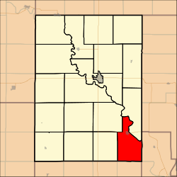 Location in Clay County | |
| Coordinates: 39°11′30″N 097°00′31″W | |
| Country | United States |
| State | Kansas |
| County | Clay |
| Area | |
| • Total | 32.26 sq mi (83.55 km2) |
| • Land | 28.24 sq mi (73.14 km2) |
| • Water | 4.02 sq mi (10.41 km2) 12.46% |
| Elevation | 1,188 ft (362 m) |
| Population (2000) | |
| • Total | 1,024 |
| • Density | 36.3/sq mi (14/km2) |
| GNIS feature ID | 0476193 |
Geography
Republican Township covers an area of 32.26 square miles (83.6 km2) and contains one incorporated settlement, Wakefield. According to the USGS, it contains one cemetery, Madura.
The streams of Cane Creek and Quimby Creek run through this township.
Transportation
Republican Township contains one airport or landing strip, Wakefield Municipal Airstrip.
gollark: Nuclear power (well, not "RTGs in all portable devices" nuclear power) is already fine cancerwise, since it doesn't really cause any outside of accidents.
gollark: Yes.
gollark: It's not *just* cancer.
gollark: I mean, sure, lots of people would be horribly irradiated, but it would be very convenient.
gollark: It's a shame there aren't really RTGs in consumer applications. The battery in my watch will theoretically need replacing in about 5 years.
External links
Municipalities and communities of Clay County, Kansas, United States | ||
|---|---|---|
| Cities |  Map of Kansas highlighting Clay County | |
| Unincorporated communities | ||
| Ghost towns | ||
| Townships | ||
| Footnotes | ‡This populated place also has portions in an adjacent county or counties | |
This article is issued from Wikipedia. The text is licensed under Creative Commons - Attribution - Sharealike. Additional terms may apply for the media files.