Exeter Township, Clay County, Kansas
Exeter Township is a township in Clay County, Kansas, USA. As of the 2000 census, its population was 81.
Exeter Township | |
|---|---|
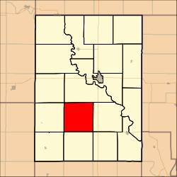 Location in Clay County | |
| Coordinates: 39°16′00″N 097°12′01″W | |
| Country | United States |
| State | Kansas |
| County | Clay |
| Area | |
| • Total | 36.19 sq mi (93.73 km2) |
| • Land | 36.16 sq mi (93.65 km2) |
| • Water | 0.03 sq mi (0.07 km2) 0.07% |
| Elevation | 1,332 ft (406 m) |
| Population (2000) | |
| • Total | 81 |
| • Density | 2.2/sq mi (0.9/km2) |
| GNIS feature ID | 0476172 |
Geography
Exeter Township covers an area of 36.19 square miles (93.7 km2) and contains no incorporated settlements. According to the USGS, it contains three cemeteries: Lutheran, Pleasant Ridge and Wesleyan.
gollark: ```pythonprint("Hello, World!")```
gollark: Yes.
gollark: Can't write bug-free if PHP has millions of bugs!
gollark: we no likely php php be bad
gollark: We need that but as an esolang. Somehow.
External links
Municipalities and communities of Clay County, Kansas, United States | ||
|---|---|---|
| Cities |  Map of Kansas highlighting Clay County | |
| Unincorporated communities | ||
| Ghost towns | ||
| Townships | ||
| Footnotes | ‡This populated place also has portions in an adjacent county or counties | |
This article is issued from Wikipedia. The text is licensed under Creative Commons - Attribution - Sharealike. Additional terms may apply for the media files.