Reisbach (Vils)
Reisbach is a market town in Bavaria. It lies on the Vils River, and belongs to the administrative region of Niederbayern.
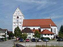 Church of St. Michael |
Reisbach | |
|---|---|
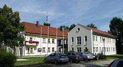 Town hall | |
.svg.png) Coat of arms | |
Location of Reisbach within Dingolfing-Landau district 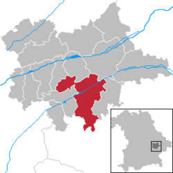 | |
 Reisbach  Reisbach | |
| Coordinates: 48°34′N 12°38′E | |
| Country | Germany |
| State | Bavaria |
| Admin. region | Niederbayern |
| District | Dingolfing-Landau |
| Subdivisions | 7 Ortsteile |
| Government | |
| • Mayor | Rolf-Peter Holzleitner (FW) |
| Area | |
| • Total | 94.16 km2 (36.36 sq mi) |
| Elevation | 408 m (1,339 ft) |
| Population (2018-12-31)[1] | |
| • Total | 7,730 |
| • Density | 82/km2 (210/sq mi) |
| Time zone | CET/CEST (UTC+1/+2) |
| Postal codes | 94419 |
| Dialling codes | 08734 08735 (Bachham) |
| Vehicle registration | DGF |
| Website | www |
Neighbouring communities
The neighbouring communities, listed clockwise, are Mamming, Landau an der Isar, Simbach (bei Landau), Falkenberg (Niederbayern), Rimbach (Niederbayern), Gangkofen, Marklkofen and Gottfrieding.
Places adjacent to Reisbach (Vils) | ||||||||||
|---|---|---|---|---|---|---|---|---|---|---|
| ||||||||||
Villages in the municipality
- Englmannsberg
- Griesbach
- Niederhausen
- Oberhausen
- Obermünchsdorf
- Reith
- Thannenmais
gollark: Not really.
gollark: Instead of, er, ~5 per keypress with ~30 on larger keyboards, although it's a bit lower since getting exactly the right button is hard.
gollark: Anyway, if you only have 9 buttons, that's slightly over 3 bits of information per keypress.
gollark: Possibly, although I don't think there are standardized autocomplete-keyboard/app interaction APIs around.
gollark: Well, you still need all the letters and symbols.
References
- "Fortschreibung des Bevölkerungsstandes". Bayerisches Landesamt für Statistik und Datenverarbeitung (in German). July 2019.
Towns and municipalities in Dingolfing-Landau | ||
|---|---|---|
| Authority control |
|
|---|
This article is issued from Wikipedia. The text is licensed under Creative Commons - Attribution - Sharealike. Additional terms may apply for the media files.