Ravensbourne, Queensland
Ravensbourne is a locality in the Toowoomba Region local government area of Darling Downs region in southern Queensland, Australia.[2] At the 2016 Australian Census, Ravensbourne and surrounds recorded a population of 248.[1]
| Ravensbourne Queensland | |||||||||||||||
|---|---|---|---|---|---|---|---|---|---|---|---|---|---|---|---|
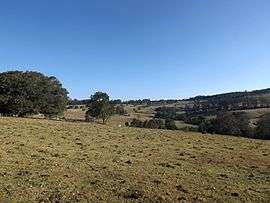 The rolling hills of Ravensbourne, 2014 | |||||||||||||||
 Ravensbourne | |||||||||||||||
| Coordinates | 27°21′S 152°9′E | ||||||||||||||
| Population | 248 (2016 census)[1] | ||||||||||||||
| Postcode(s) | 4352 | ||||||||||||||
| LGA(s) | Toowoomba Region | ||||||||||||||
| State electorate(s) | Condamine | ||||||||||||||
| Federal Division(s) | Maranoa | ||||||||||||||
| |||||||||||||||
Geography
The locality is crossed from east to west by the Esk–Hampton Road.
In the far north is reservoir created behind the Cressbrook Dam. Most of the area is within the catchment of the dammed Cressbrook Creek, a tributary of the Brisbane River. However a small section in the southeast lies within the Lockyer Creek catchment. In this part lies the Ravensbourne National Park. In the west Preserverance Creek marks the boundary.
gollark: I do like having an ISP which, while quite slow, happily lets us just download terabytes a month with no problems.
gollark: Oh wow, that is pretty bad.
gollark: Internet connection speeds are mostly measured in Mbps. Which is frustrating, because I mostly use MB.
gollark: In many cases, it's more useful to have a somewhat large binary *now* than a hyperoptimized small one much later.
gollark: We already ran into netsplits or something after one of the two servers went down. This is very IRC.
References
- Australian Bureau of Statistics (27 June 2017). "Ravensbourne (State Suburb)". 2016 Census QuickStats. Retrieved 18 March 2018.

- "Ravensbourne - locality (entry 48050)". Queensland Place Names. Queensland Government. Retrieved 26 June 2017.
This article is issued from Wikipedia. The text is licensed under Creative Commons - Attribution - Sharealike. Additional terms may apply for the media files.