Radobolja
Radobolja is a river in Bosnia and Herzegovina. It is five kilometers long and its spring is located below the Mikuljača hill in Mostar's suburb of Ilići.[1] Radobolja flows through Mostar and flows into the Neretva River near the Old Bridge.[2] During the Ottoman rule water from Radobolja was used for irrigation and drinking, however today's Radobolja is polluted due to discharge of waste-water.[3]
| Radobolja | |
|---|---|
 Radobolja River | |
| Location | |
| Country | Bosnia and Herzegovina |
| Physical characteristics | |
| Source | |
| • location | Mikuljača hill in Mostar's suburb of Ilići |
| Mouth | |
• location | Neretva |
• coordinates | 43.3367°N 17.8150°E |
| Length | 5 km (3.1 mi) |
| Basin features | |
| Progression | Neretva→ Adriatic Sea |
Gallery
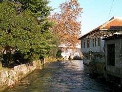
 Radobolja river in Mostar
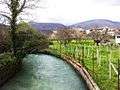 Ilići and river Radobolja in Mostar
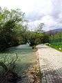
 Radobolja river in Ilići, Mostar
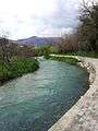 Radobolja river in Ilići, Mostar
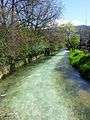 Radobolja river in Mostar
gollark: 🌵 🌵 🐷 🐷 🌵 🌵 🌵 🌵 🐷 #⃣ 🐷 🌵 🌵 🌵 🐷 🐷 #⃣ #⃣ 🌵 🌵 🐷 🐷 🐷 🐷 🌵 🌵 #⃣ 🌵 #⃣ 🐷 🌵 🌵 🐷 🐷 #⃣ 🐷 🌵 🌵 🐷 #⃣ 🐷 🌵 🌵 🌵 #⃣ 🌵 #⃣ 🐷 🌵 🌵 🐷 🐷 🌵 #⃣ 🌵 🌵 #⃣ 🌵 #⃣ 🐷 🌵 🌵 🐷 #⃣ #⃣ #⃣ 🌵 🌵 🐷 #⃣ 🌵 🐷 🌵 🌵 🐷 🐷 🐷 🌵 🌵 🌵 #⃣ 🌵 #⃣ 🐷 🌵 🌵 🐷 🐷 🐷 #⃣ 🌵 🌵 🐷 🐷 🐷 🌵 🌵 🌵 🐷 🐷 #⃣ #⃣ 🌵 #⃣ 🌵 🌵 🐷 🐷 🌵 🌵 #⃣ 🌵 #⃣ 🐷 🌵 #⃣ 🌵 🌵 🌵 🐷 🌵 🌵 🐷 🐷 🐷 🐷 🌵 🌵 🐷 #⃣ 🐷 🌵 🌵 🌵 🐷 #⃣ 🌵 🐷 🌵 🌵 🐷 🐷 #⃣ 🌵 🌵 🌵 #⃣ 🌵 #⃣ 🐷 🌵 🌵 🐷 🐷 🌵 #⃣ 🌵 🌵 🐷 🐷 🐷 🌵 🌵 🌵 #⃣ 🌵 #⃣ 🐷 🌵 🌵 🐷 #⃣ 🐷 🌵 🌵 🌵 🐷 🐷 #⃣ 🐷 🌵 🌵 🐷 🐷 🐷 #⃣ 🌵 🌵 🐷 🐷 🌵 🐷 🌵 🌵 🐷 🐷 🌵 #⃣ 🌵 #⃣ 🌵 🌵 🌵 🐷
gollark: But I was going on holiday to ||Berlin|| tomorrow!
gollark: RX 570s are much better if you have a PSU cable for them.
gollark: øĸæy
gollark: The only evil developer-related conspiracy is the one to make Firefox on Linux not do hardware accelerated video decoding.
References
- Most Magazine: Oasis That no Longer Exists (in local language) [cited April 19, 2012] Archived August 27, 2013, at the Wayback Machine
- Mostar Fair: About Mostar [cited April 19, 2012] Archived June 28, 2012, at the Wayback Machine
- Ribolov Online: Today's Radobolja is Something Else (in local language) [cited April 19, 2012]
| Countries |   | ||||||||||||||||
|---|---|---|---|---|---|---|---|---|---|---|---|---|---|---|---|---|---|
| Places | |||||||||||||||||
| Wellsprings |
| ||||||||||||||||
| Tributaries |
| ||||||||||||||||
| Lakes |
| ||||||||||||||||
| Hydroelectric Power Plants |
| ||||||||||||||||
| Related articles | |||||||||||||||||
| Trebišnjica drainage: sub-basin of the Neretva |
| ||||||||||||||||
This article is issued from Wikipedia. The text is licensed under Creative Commons - Attribution - Sharealike. Additional terms may apply for the media files.