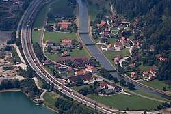
Röthelstein
Röthelstein is a former municipality in the district of Graz-Umgebung in the Austrian state of Styria. Since the 2015 Styria municipal structural reform, it is part of the municipality Frohnleiten.[2]
Röthelstein | |
|---|---|
 | |
 Coat of arms | |
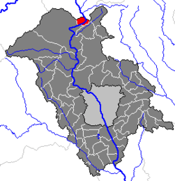 Location within Graz-Umgebung district | |
 Röthelstein Location within Austria | |
| Coordinates: 47°18′31″N 15°22′04″E | |
| Country | Austria |
| State | Styria |
| District | Graz-Umgebung |
| Government | |
| • Mayor | Heinz-Johann Glössl (WLR) |
| Area | |
| • Total | 7.01 km2 (2.71 sq mi) |
| Elevation | 449 m (1,473 ft) |
| Population (1 January 2016)[1] | |
| • Total | 210 |
| • Density | 30/km2 (78/sq mi) |
| Time zone | UTC+1 (CET) |
| • Summer (DST) | UTC+2 (CEST) |
| Postal code | 8131 |
| Area code | 03867 |
| Vehicle registration | GU |
| Website | www.roethelstein.at |
Population
| Year | Pop. | ±% |
|---|---|---|
| 1869 | 261 | — |
| 1880 | 236 | −9.6% |
| 1890 | 213 | −9.7% |
| 1900 | 221 | +3.8% |
| 1910 | 176 | −20.4% |
| 1923 | 214 | +21.6% |
| 1934 | 237 | +10.7% |
| 1939 | 208 | −12.2% |
| 1951 | 247 | +18.8% |
| 1961 | 235 | −4.9% |
| 1971 | 244 | +3.8% |
| 1981 | 219 | −10.2% |
| 1991 | 213 | −2.7% |
| 2001 | 223 | +4.7% |
gollark: I have never found petramor to actually work well.
gollark: It might run on things with fewer than a terabyte of RAM and 6 cores, which is good.
gollark: Or just forgot to. I hope.
gollark: I know, who thought that was a good idea?!
gollark: There seems to be one, and only one, industrial mod with power and stuff, called Technic.
References
This article is issued from Wikipedia. The text is licensed under Creative Commons - Attribution - Sharealike. Additional terms may apply for the media files.