Prairie Township, Boone County, Arkansas
Prairie Township is one of twenty current townships in Boone County, Arkansas, USA.[1] As of the 2010 census, its total population was 444.
Prairie Township | |
|---|---|
 Prairie Township Location in Arkansas | |
| Coordinates: 36°9′19.06″N 92°54′54.74″W | |
| Country | |
| State | |
| County | Boone |
| Area | |
| • Total | 16.272 sq mi (42.14 km2) |
| • Land | 16.266 sq mi (42.13 km2) |
| • Water | 0.006 sq mi (0.02 km2) |
| Population (2010) | |
| • Total | 444 |
| • Density | 27.36/sq mi (10.56/km2) |
| Time zone | UTC-6 (CST) |
| • Summer (DST) | UTC-5 (CDT) |
| Zip Code | 72633 (Everton) |
| Area code(s) | 870 |
Geography
According to the United States Census Bureau, Omaha Township covers an area of 78.986 square miles (204.57 km2); 77.985 square miles (201.98 km2) of land and 1.001 square miles (2.59 km2) of water.
Cities, towns, and villages
Population history
Figures below include the population of the incorporated town of Everton.
| Census | Population |
|---|---|
| 2010 | 444 |
| 2000 | 487 |
| 1990 | 436 |
| 1980 | 433 |
| 1970 | 367 |
| 1960 | 348 |
| 1950 | 503 |
| 1940 | 579 |
| 1930 | 530 |
| 1920 | 721 |
| 1910 | 670 |
| 1900 | 500 |
| 1890 | 617 |
| 1880 | 667 |
| 1870 | 1,214 |
| 1860 (area part of Carroll County at the time) | 1,205 |
| 1850 (area part of Carroll County at the time) | 1,131 |
gollark: Wow, I've created an amazing amount of errors so far!
gollark: Probably.
gollark: I'll try without the function environment meddlings and see.
gollark: The old version literally ran the entire BIOS to put everything in the environment, starting from just FS functions and a whitelisted set of libraries. The new version is attempting to just change the envs of all the functions round, not that that works at all.
gollark: Indeed.
References
- United States Census Bureau 2008 TIGER/Line Shapefiles
- United States Board on Geographic Names (GNIS)
- United States National Atlas
- "Prairie Township, Boone County, Arkansas." U.S. Census Bureau. Breakdown. Retrieved June 2, 2012.
External links
Municipalities and communities of Boone County, Arkansas, United States | ||
|---|---|---|
| Cities | 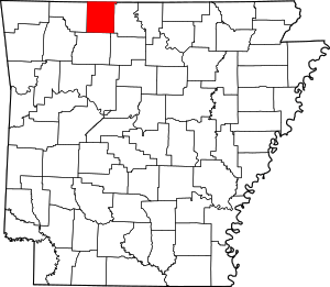 Map of Arkansas highlighting Boone County | |
| Towns | ||
| Townships | ||
| Unincorporated communities | ||
| Ghost town | ||
| Footnotes | ‡This populated place also has portions in an adjacent county or counties | |
This article is issued from Wikipedia. The text is licensed under Creative Commons - Attribution - Sharealike. Additional terms may apply for the media files.