Poznań Fast Tram
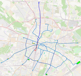
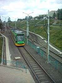
Poznański Fast Tram (Polish: Poznański Szybki Tramwaj, PST, informally: PeSTka) is a 8.1-kilometre (5.0 mi) stretch of grade-separated tram/light rail line in Poznań, Poland. The tracks are set in a cutting or on an overpass, switches allowing to drive on adjacent tracks. The stops, resembling railroad stations, have a different colour scheme each. This tram line was created as an alternative to a more expensive metro. The PST, opened in 1997, links the densely populated northern districts of Winogrady and Piątkowo with the city centre. It is served by lines 12, 14, 15 and 16, as well as by the night line N201.
Poznański Szybki Tramwaj | ||||||||||||||||||||||||||||||||||||||||||||||||||||||||||||||||||||||||||||||||||||||||||||||||||
|---|---|---|---|---|---|---|---|---|---|---|---|---|---|---|---|---|---|---|---|---|---|---|---|---|---|---|---|---|---|---|---|---|---|---|---|---|---|---|---|---|---|---|---|---|---|---|---|---|---|---|---|---|---|---|---|---|---|---|---|---|---|---|---|---|---|---|---|---|---|---|---|---|---|---|---|---|---|---|---|---|---|---|---|---|---|---|---|---|---|---|---|---|---|---|---|---|---|---|
| ||||||||||||||||||||||||||||||||||||||||||||||||||||||||||||||||||||||||||||||||||||||||||||||||||
| ||||||||||||||||||||||||||||||||||||||||||||||||||||||||||||||||||||||||||||||||||||||||||||||||||


System
- Length: 6.1 kilometres (3.8 mi)
- Number of stops: 6
- Maximum speed: 70-kilometre-per-hour (43 mph)
- Capacity: 5000 persons per hour
- Trams run every 2.5 minutes during the rush hours, otherwise every 5 minutes
Background

Poznań is a city of 580,000 inhabitants, with about 200,000 more living in the suburbs. Most of the city's office buildings are located in the centre, while most light industry is located uptown or in the suburbs around the city. Hence most trips by public transport are to and from the centre.
History
The first Poznań public transport company started its business activity in 1880, with a few horse-pulled trams. At that time, the town had about 70,000 inhabitants, and was not growing due to building restrictions imposed by the Prussian military administration creating Festung Posen ("Poznań Stronghold"), see Poznań in the Kingdom of Prussia (1793–1918).
Soon after the company was established, the construction limitations were lifted, and the town grew very fast to about 200,000 inhabitants in 1920s. By that time there were some early ideas of creating a segregated line that would link the centre with one of the northern districts. Neither technology nor the budget allowed for a construction of such a tram line, and metro, as in Berlin, would have been too ambitious and unnecessary, so the plans were shelved.
In the 1960s and 1970s, Poland's communist government built blocks of flats in the north and east of the city. This created a high population density and thus a high demand for transportation. However, these districts were poorly served by public transport: it took up to 45 minutes by bus to travel to the city center. A corridor was left for the construction of a tram line. The construction work commenced in 1975, progressed very slowly, finally stalling at 60%[1] in 1990, after the fall of communism. Construction resumed in 1993, and the entire project was ready by the end of 1996.
Originally, the line was meant to be separate from the tram network, with a terminus in the city centre. Then a decision was made to connect to the existing tram network.
Present day
The line opened on February 1, 1997. Travel times between the northern districts and the centre decreased from about 40 minutes to some 10–15 minutes. This, combined with limited and paid parking space in the centre, contributed to the huge success of the line, with overcrowding at peak times. In 1999, another service (no. 16) was added, but the capacity of the operation is reaching its limits. With the new line 16, trams run every 2.5 minutes at peak times, and as the line has not been fitted with a train protection system, for safety reasons there cannot be any more trams per hour than there are now.
The trams suffered from vandalism and from a lack of security. These problems, however, diminished when surveillance cameras were installed. The project has had a very positive impact on the communities it serves, making them more attractive for investors, and stopping depopulation.
Some institutions and companies served by the tram, listed by station, include: (those marked by a plus (+) have moved in the general area after the opening of the line):
- Słowiańska (green) — student dormitories, Courts of Law (+)
- Al. Solidarności (previously Serbska; yellow) — 3 supermarkets (+), a large office building (+)
- Lechicka/Poznań Plaza (previously Lechicka; blue) — a supermarket (+), Poznań Plaza shopping mall (+)
- Kurpińskiego (orange) — a bank (+), a small supermarket, a clinic
- Szymanowskiego (red) — a supermarket (+), and a large development of modern apartment blocks
- Osiedle Jana III Sobieskiego (terminus) — Adam Mickiewicz University campus
Current lines
| # | Stops |
|---|---|
| Regular line | |
| 12 | OS. JANA III SOBIESKIEGO – Trasa PST – Dworzec Zachodni – Głogowska – Most Dworcowy – Matyi – Królowej Jadwigi – Krzywoustego – rondo Rataje – Ludwika Zamenhofa – rondo Starołęka – Starołęcka – STAROŁĘKA |
| 14 | OS. JANA III SOBIESKIEGO – Trasa PST – Dworzec Zachodni – Głogowska – GÓRCZYN |
| 15 | OS. JANA III SOBIESKIEGO – Trasa PST – Roosevelta – Grunwaldzka – rondo Nowaka-Jeziorańskiego – Grunwaldzka – BUDZISZYŃSKA |
| 16 | OS. JANA III SOBIESKIEGO – Trasa PST – Roosevelta – Most Teatralny – Fredry – Gwarna – Św. Marcin – Al. Marcinkowskiego – Podgórna – Dowbora-Muśnickiego – Mostowa – Kórnicka – Trasa Kórnicka – Piaśnicka – FRANOWO |
| Night line | |
| 201 | OS. JANA III SOBIESKIEGO – Trasa PST – Most Teatralny – Roosevelta – Fredry – Gwarna – Św. Marcin – Al. Marcinkowskiego – Podgórna – Dowbora-Muśnickiego – Mostowa – Most Św. Rocha – Kórnicka – Trasa Kórnicka – OS. LECHA – Górny Taras Rataj – Hetmańska – rondo Starołęka – Zamenhofa – rondo Rataje – Jana Pawła II – Kórnicka – Most św. Rocha – Mostowa – Dowbora-Muśnickiego – Podgórna – Al. Marcinkowskiego – 27 Grudnia – Fredry – Roosevelta – Trasa PST – OS. JANA III SOBIESKIEGO |
Future development
Future development of Poznański Szybki Tramwaj | |||||||||||||||||||||||||||||||||||||||||||||||||||||||||||||||||||||||||||||||||||||||||||||||||||||||||||||||||||||||||||||||||||||||||||||||||||||||
|---|---|---|---|---|---|---|---|---|---|---|---|---|---|---|---|---|---|---|---|---|---|---|---|---|---|---|---|---|---|---|---|---|---|---|---|---|---|---|---|---|---|---|---|---|---|---|---|---|---|---|---|---|---|---|---|---|---|---|---|---|---|---|---|---|---|---|---|---|---|---|---|---|---|---|---|---|---|---|---|---|---|---|---|---|---|---|---|---|---|---|---|---|---|---|---|---|---|---|---|---|---|---|---|---|---|---|---|---|---|---|---|---|---|---|---|---|---|---|---|---|---|---|---|---|---|---|---|---|---|---|---|---|---|---|---|---|---|---|---|---|---|---|---|---|---|---|---|---|---|---|---|
| |||||||||||||||||||||||||||||||||||||||||||||||||||||||||||||||||||||||||||||||||||||||||||||||||||||||||||||||||||||||||||||||||||||||||||||||||||||||
| |||||||||||||||||||||||||||||||||||||||||||||||||||||||||||||||||||||||||||||||||||||||||||||||||||||||||||||||||||||||||||||||||||||||||||||||||||||||
Similar fast tram networks exist in other parts of the world — namely in Vienna, Amsterdam, and Brussels — while several other cities, beginning with Karlsruhe, have used mainline railway tracks to expand their tram networks. However, those cities are much larger and have gone further towards the development of trams into metro-style, heavier vehicles. It was therefore important for the Poznań administration to find out on their own how successful the program would be.
As the program had proved successful, another extension started in early 2005, connecting the city centre with eastern high-rise districts. It is not truly a fast tram on the same scale, but the success of the first program has prompted the authority to convert an existing line into a faster one.
References
- Andrzej KRYCH SZYBKI I SZYBSZY TRAMWAJ - EWALUACJA IDEI I APLIKACJI NA PRZYKLADZIE POZNANIA