Portuense (Suburb of Rome)
Portuense is the seventh Suburb of Rome (Italy), identified as S. VII.
The name is associated with the Quartiere with the same name and derives - as for the Quartiere - from the Via Portuense, which connected Rome to Portus.
S. VII Portuense | |
|---|---|
The Magliana railway station, inside the Suburb. | |
 Flag | |
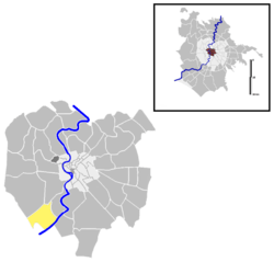
 Location of Suburbio Portuense in Rome. | |
| Region | Lazio |
| Comune | Rome |
| Area | |
| • Total | 7.4311 km2 (2.8692 sq mi) |
| Population (2016)[1] | |
| • Total | 33,803 |
| • Density | 4,549/km2 (11,780/sq mi) |
| Time zone | UTC+1 (CET) |
| • Summer (DST) | UTC+2 (CEST) |
| Area code(s) | 307 |
Geography
Territory
The Suburb is located in the south-west area of the town, between Via Portuense in the north and the river Tiber in the south.
The Suburb borders:
- to the north, the Suburb S. VIII Gianicolense (along Via Portuense, between Via del Fosso della Magliana and Via del Trullo) and the Quartiere Q. XII Gianicolense (along Via Portuense, between Via del Trullo and Largo Gaetano la Loggia).
- to the east, the Quartiere Q. XI Portuense, from which it is separated, starting from Via Portuense, by Largo Gaetano la Loggia, Via Pietro Frattini, via dell'Imbrecciato up to Via della Magliana, then by the viaduct of Magliana up to the bridge on the Tiber.
- to the south-east, the Quartiere Q. XXXII Europa (along the Tiber, between Ponte della Magliana and the point 41.831683°N 12.449835°E) and the Zone Z. XXXIX Tor di Valle (along the Tiber, between the point 41.831683°N 12.449835°E and the confluence of the Magliana) 41.828569°N 12.420801°E.
- to the west, the Zone Z. XL Magliana Vecchia (along Via del Fosso della Magliana, starting from the confluence of the Magliana and the Tiber up to Via Portuense).
The urban zone 15D Trullo is encompassed by the Suburb, which also includes the historic area called La Parrocchietta.
History
The Suburb was established with Council Resolution nr. 20 of 20 August 1921, which assigned it the numbering S. VIII and the toponymic code 308; then it assumed the current numbering and code following the suppression of the Suburb S. VII Ostiense, due to the variation of the toponymic dictionary of March 1, 1954.
Monuments and places of interest
Civil buildings
- Villa Kock, on the hill of Monte Cucco. 17th-century villa (1607). 41.836249°N 12.441293°E
- Casale Ascenzi, in Via dell'Imbrecciato. 18th-century farmhouse. 41.849416°N 12.445149°E
- Torre Righetti, on the hill of Monte Cucco. 19th-century hunting lodge (1825). 41.836589°N 12.443951°E. The building appears in the movie The Hawks and the Sparrows by Pier Paolo Pasolini (1966).
- Casale degli Inglesi, in Via di Generosa. 19th-century farmhouse. 41.838166°N 12.425148°E
- Casa Pantalei, in Via delle Vigne. 19th-century farmhouse. 41.841171°N 12.422417°E
- Casale Lauricella, in Via Adeodato Ressi. 19th-century farmhouse. 41.844743°N 12.426332°E
- Casale Maccaferri, in Via Fulda. 19th-century farmhouse. 41.838035°N 12.432258°E
Religious buildings
- Santa Maria del Rosario di Pompei alla Magliana, in Piazza della Madonna di Pompei. 20th-century church (1915).
- San Raffaele Arcangelo, in Via di San Raffaele. 20th-century church (1953). 41.843758°N 12.437982°E: parish church erected on February 1, 1953 by Decree "Quo uberius" of Cardinal Vicar Clemente Micara.
- Cappella Gesù Maestro della Casa Generalizia Congregazione delle Pie Discepole del Divin Maestro, in Via Portuense. 20th-century church (1967-69). 41.850433°N 12.428936°E
- Santa Maria del Rosario, in Via Chiusdino. 21th-century church (2007).
Archaeological sites
- Torraccio (or Trullo) dei Massimi, in Via delle Idrovore della Magliana. 1st-century sepulcher. 41.830352°N 12.445644°E
- Hypogean basilica and Catacombs of Generosa, in Via delle Catacombe di Generosa. 4th-century basilica and sepulcher.
Other
- Ponte della Magliana, along Via della Magliana. 20th-century bridge (1930-48).
- Memorial to the fallen of the Great War from Trullo and Magliana, in Via del Trullo. 41.841965°N 12.437143°E
Infrastructures and transport

Notes
- Roma Capitale - Roma Statistica. Population inscribed in the resident register at 31 December 2016 by toponymy subdivision.
External links
- "Municipio Roma XI". Roma Capitale.
- "Basilica e Catacomba di Generosa". Sovrintendenza Capitolina ai Beni Culturali. Archived from the original on September 10, 2014. Retrieved September 10, 2014.
- "Catacombe di Generosa". Roma Sotterranea.
- Antonello Anappo. "Catacombe di Generosa". Arvalia Storia.
- Antonello Anappo. "Torre Righetti". Arvalia Storia.
- Antonello Anappo. "Trullo dei Massimi". Arvalia Storia.
- Antonello Anappo. "Villa Kock". Arvalia Storia.
- "La Roma di Pasolini - Torre Righetti". Pasolini.net. Archived from the original on July 7, 2014.