Ponderosa Pine, New Mexico
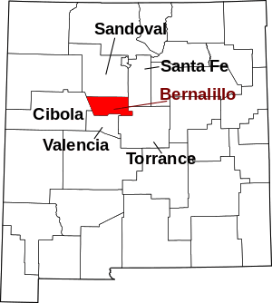
Ponderosa Pine is a census-designated place (CDP) in Bernalillo County, New Mexico, United States. The population was 1,195 at the 2010 census.[1] It is part of the Albuquerque Metropolitan Statistical Area.
Ponderosa Pine, New Mexico | |
|---|---|
 Ponderosa Pine | |
| Coordinates: 34°58′17″N 106°20′5″W | |
| Country | United States |
| State | New Mexico |
| County | Bernalillo |
| Area | |
| • Total | 8.1 sq mi (20.9 km2) |
| • Land | 8.1 sq mi (20.9 km2) |
| • Water | 0.0 sq mi (0.0 km2) |
| Elevation | 7,440 ft (2,270 m) |
| Population (2010) | |
| • Total | 1,195 |
| • Density | 148/sq mi (57.2/km2) |
| Time zone | UTC-7 (Mountain (MST)) |
| • Summer (DST) | UTC-6 (MDT) |
| Area code(s) | 505 |
| FIPS code | 35-59120 |
| GNIS feature ID | 0909790 |
Geography
Ponderosa Pine is located in southeastern Bernalillo County. It is bordered to the north by the Cedro census-designated place, and to the west by Cibola National Forest. New Mexico State Road 337 leads through the community, leading north 10 miles (16 km) to Tijeras and Interstate 40.
According to the United States Census Bureau, the Ponderosa Pine CDP has a total area of 8.1 square miles (20.9 km2), all of it land.[1]
gollark: Fine, I'll check more random webpages.
gollark: A random webpage says coal plants are about 35% efficient.
gollark: Why should it be the other way round? If one of those options is actually substantially better, shouldn't that just be used in both places?
gollark: I thought it only lasted a few years in normal conditions.
gollark: * proportion
References
- "Geographic Identifiers: 2010 Demographic Profile Data (G001): Ponderosa Pine CDP, New Mexico". U.S. Census Bureau, American Factfinder. Archived from the original on February 12, 2020. Retrieved January 30, 2014.
This article is issued from Wikipedia. The text is licensed under Creative Commons - Attribution - Sharealike. Additional terms may apply for the media files.
