Polonnaruwa District
Polonnaruwa District (Sinhala: පොළොන්නරුව දිස්ත්රික්කය; Tamil: பொலன்னறுவை மாவட்டம்) is one of the 25 districts of Sri Lanka, the second level administrative division of the country. It is also one of the two districts of North Central Province and has an area of 3,293 km².[7]
Polonnaruwa District පොළොන්නරුව දිස්ත්රික්කය பொலன்னறுவை மாவட்டம் | |
|---|---|
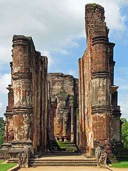
 Lankatilaka Vihara | |
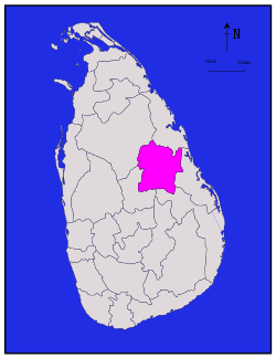
 Map of Sri Lanka with Polonnaruwa District highlighted | |
| Coordinates: 8°00′N 81°00′E | |
| Country | Sri Lanka |
| Province | North Central Province |
| Largest Town | Polonnaruwa |
| DS Division[1] | List
|
| Government | |
| • District Secretary | W. A. Dharmasiri |
| • MPs | |
| • MPCs[2] | List
|
| Area | |
| • Total | 3,293 km2 (1,271 sq mi) |
| • Land | 3,077 km2 (1,188 sq mi) |
| • Water | 216 km2 (83 sq mi) 6.55% |
| Area rank | 5th (5.01% of total area) |
| Population (2012)[4] | |
| • Total | 403,335 |
| • Density | 120/km2 (320/sq mi) |
| Ethnicity | |
| • Sinhalese | 365,476 (90.6%) |
| • Moors | 29,060 (7.2%) |
| • Sri Lankan Tamil | 7,356 (1.8%) |
| • Indian Tamil | 1,190 (0.3%) |
| • Other | 253 (0.06%) |
| Religion | |
| • Buddhist | 361,920 (89.7%) |
| • Muslim | 30,427 (7.5%) |
| • Hindu | 6,835 (1.7%) |
| • Christian | 4,090 (1.00%) |
| • Other | 63 (0.01%) |
| Time zone | UTC+05:30 (Sri Lanka) |
| Post Codes | 51000 |
| Telephone Codes | 027 |
| ISO 3166 code | LK-72 |
| Vehicle registration | NC |
| Official Languages | Sinhala, Tamil |
The district is administered by a District Secretariat headed by a District Secretary (previously known as a Government Agent) appointed by the central government of Sri Lanka. The capital of the district is the city of Polonnaruwa.
Demographics
Education
Following are some of the schools in the Polonnaruwa District.
- Polonnaruwa Rajakeeya Madya Maha Vidyalaya
- Thopawewa Maha Vidyalayaya
- Bakamuna Mahasen Isuru College
- PL/Polonnaruwa Muslim Central College - Kaduruwela
- PL/Vijitha Central College
Towns
- Polonnaruwa-Kaduruwela
- Hingurakgoda
- Minneriya
- Bakamuna
- Aralaganwila
- Medirigiriya
- Giritale
- Elahera
- Jayantipura
- Galamuna
- Lankapura
- Sungawila
- Manampitiya
- Welikanda
- Dimbulagala
gollark: http://sed.sourceforge.net/grabbag/scripts/turing.sed
gollark: SQLite3.
gollark: 🌙 🌜 🌑 🌚 🌕 🌜 🌜 🌗 🌝 🌝 🌓 🌜 🌓 🌚 🌕 🌑 🌚 🌕 🌝 🌜 🌕 🌕 🌙 🌚 🌜 🌝 🌜 🌚 🌙 🌝
gollark: I'm retrieving it from the database.
gollark: Added to your lunar profile.
References
- https://www.citypopulation.de/php/srilanka-admin.php?adm1id=72
- http://www.nc.gov.lk/en/about-us/provincial-cabinet.html
- https://web.archive.org/web/20121113190301/http://www.statistics.gov.lk/Abstract2011/CHAP1/AB1-1.pdf
- http://www.statistics.gov.lk/PopHouSat/CPH2011/index.php?fileName=pop43&gp=Activities&tpl=3%20The%20Census%20of%20Population%20and%20Housing%20of%20Sri%20Lanka-2011
- http://www.statistics.gov.lk/PopHouSat/CPH2011/index.php?fileName=pop42&gp=Activities&tpl=3
- http://www.statistics.gov.lk/PopHouSat/CPH2011/index.php?fileName=pop43&gp=Activities&tpl=3
- http://coins.lakdiva.org/d25/districts.html
- http://www.statistics.gov.lk/PopHouSat/CPH2011/index.php?fileName=pop42&gp=Activities&tpl=3%20The%20Census%20of%20Population%20and%20Housing%20of%20Sri%20Lanka-2011
- http://www.statistics.gov.lk/PopHouSat/CPH2011/index.php?fileName=pop42&gp=Activities&tpl=3%20The%20Census%20of%20Population%20and%20Housing%20of%20Sri%20Lanka-2011
- Department of Census and Statistics,The Census of Population and Housing of Sri Lanka-2011
This article is issued from Wikipedia. The text is licensed under Creative Commons - Attribution - Sharealike. Additional terms may apply for the media files.