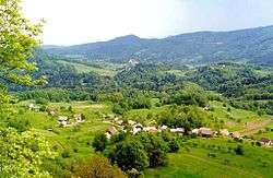
Podpeč pri Šentvidu
Podpeč pri Šentvidu (pronounced [pɔtˈpeːtʃ pɾi ʃɛnˈtʋiːdu] or [pɔtˈpeːtʃ pɾi ʃənˈtʋiːdu]) is a settlement just east of Šentvid pri Planini in the Municipality of Šentjur in eastern Slovenia. The area is part of the traditional region of Styria and is now included in the Savinja Statistical Region.[2]
Podpeč pri Šentvidu | |
|---|---|
 | |
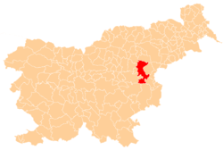
 Podpeč pri Šentvidu Location in Slovenia | |
| Coordinates: 46°5′48.61″N 15°26′43.52″E | |
| Country | |
| Traditional region | Styria |
| Statistical region | Savinja |
| Municipality | Šentjur |
| Area | |
| • Total | 1.76 km2 (0.68 sq mi) |
| Elevation | 541.2 m (1,775.6 ft) |
| Population (2002) | |
| • Total | 69 |
| [1] | |
Name
The name of the settlement was changed from Podpeč to Podpeč pri Šentvidu in 1953.[3]
gollark: foronhoit.
gollark: I am going to need to make it use sensible units, then.
gollark: I see.
gollark: I wonder what units.
gollark: Why does my CPU temperature monitor say 58 degrees something?
References
- Statistical Office of the Republic of Slovenia
- Šentjur municipal site Archived 2011-01-15 at the Wayback Machine
- Spremembe naselij 1948–95. 1996. Database. Ljubljana: Geografski inštitut ZRC SAZU, DZS.
External links
- Podpeč pri Šentvidu at Geopedia

This article is issued from Wikipedia. The text is licensed under Creative Commons - Attribution - Sharealike. Additional terms may apply for the media files.