Hotunje
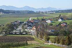
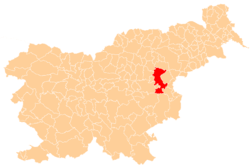
Hotunje (pronounced [xɔˈtuːnjɛ]) is a village west of Ponikva in the Municipality of Šentjur in eastern Slovenia. The area is part of the historical region of Styria and is included in the Savinja Statistical Region.[2]
Hotunje | |
|---|---|
 | |
 Hotunje Location in Slovenia | |
| Coordinates: 46°15′6.03″N 15°25′24.47″E | |
| Country | |
| Traditional region | Styria |
| Statistical region | Savinja |
| Municipality | Šentjur |
| Area | |
| • Total | 2.1 km2 (0.8 sq mi) |
| Elevation | 309.8 m (1,016.4 ft) |
| Population (2002) | |
| • Total | 279 |
| [1] | |
The railway line from Ljubljana to Maribor runs along the eastern edge of the settlement. The local railway station dates to the time the Austrian Southern Railway was being built between 1845 and 1846.[3]
Notable people
Notable people that were born or lived in Hotunje include:
- Blasius Kozenn (1821–1871), geographer and cartographer
gollark: They need to be able to operate independently of the network, or everything will go horribly wrong if they go into a tunnel, or there's a temporary outage.
gollark: Honestly it doesn't seem useful for *that*, either.
gollark: I can see it being used for specialty applications like that, sure, but it does *not* seem useful in a generic router-type device.
gollark: It honestly seems mostly pointless though, given that it doesn't go through walls and apparently works at roughly... cable ranges.
gollark: I've never heard it called WiFi type C, I thought it was just 802.11ad or something.
References
- Statistical Office of the Republic of Slovenia
- Šentjur municipal site Archived 2011-01-15 at the Wayback Machine
- Slovenian Ministry of Culture register of national heritage reference number ešd 27477
External links

- Hotunje at Geopedia
This article is issued from Wikipedia. The text is licensed under Creative Commons - Attribution - Sharealike. Additional terms may apply for the media files.