Pike Township, Perry County, Ohio
Pike Township is one of the fourteen townships of Perry County, Ohio, United States. The 2000 census found 6,595 people in the township, 1,906 of whom lived in the unincorporated portions of the township.[3]
Pike Township, Perry County, Ohio | |
|---|---|
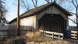 Bowman Mill Covered Bridge at the county fairgrounds | |
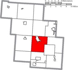 Location of Pike Township in Perry County | |
| Coordinates: 39°42′22″N 82°12′10″W | |
| Country | United States |
| State | Ohio |
| County | Perry |
| Area | |
| • Total | 32.6 sq mi (84.4 km2) |
| • Land | 32.0 sq mi (82.8 km2) |
| • Water | 0.6 sq mi (1.6 km2) |
| Elevation | 932 ft (284 m) |
| Population (2000) | |
| • Total | 6,595 |
| • Density | 206.2/sq mi (79.6/km2) |
| Time zone | UTC-5 (Eastern (EST)) |
| • Summer (DST) | UTC-4 (EDT) |
| FIPS code | 39-62680[2] |
| GNIS feature ID | 1086787[1] |
Geography
Located in the central part of the county, it borders the following townships:
- Clayton Township - north
- Harrison Township - northeast
- Bearfield Township - east
- Pleasant Township - southeast
- Salt Lick Township - south
- Monday Creek Township - southwest corner
- Jackson Township - west
- Reading Township - northwest corner
The city of New Lexington, the county seat of and only city in Perry County, is located in northern Pike Township, and the unincorporated community of Bristol lies in the township's south.
Name and history
Pike Township was organized around 1814, and named for Zebulon Pike, a United States Army captain.[4] It is one of eight Pike Townships statewide.[5]
Government
The township is governed by a three-member board of trustees, who are elected in November of odd-numbered years to a four-year term beginning on the following January 1. Two are elected in the year after the presidential election and one is elected in the year before it. There is also an elected township fiscal officer,[6] who serves a four-year term beginning on April 1 of the year after the election, which is held in November of the year before the presidential election. Vacancies in the fiscal officership or on the board of trustees are filled by the remaining trustees.
References
- "US Board on Geographic Names". United States Geological Survey. 2007-10-25. Retrieved 2008-01-31.
- "U.S. Census website". United States Census Bureau. Retrieved 2008-01-31.
- Perry County, Ohio — Population by Places Estimates Ohio State University, 2007. Accessed 15 May 2007.
- Colborn, Ephraim S. (1883). History of Fairfield and Perry Counties, Ohio: Their Past and Present. Brookhaven Press. p. 226.
- "Detailed map of Ohio" (PDF). United States Census Bureau. 2000. Retrieved 2007-02-16.
- §503.24, §505.01, and §507.01 of the Ohio Revised Code. Accessed 4/30/2009.
External links
Municipalities and communities of Perry County, Ohio, United States | ||
|---|---|---|
| Villages |  Map of Ohio highlighting Perry County | |
| Townships | ||
| CDPs | ||
| Unincorporated communities | ||
| Ghost towns | ||
| Footnotes | ‡This populated place also has portions in an adjacent county or counties | |
| Authority control |
|
|---|