Phunphin District
Phunphin (Thai: พุนพิน, pronounced [pʰūn.pʰīn]) is a district (amphoe) in Surat Thani Province in the south of Thailand. Tha Kham is the principal town of the district. In 2014, the population was 73,067.[1]
Phunphin พุนพิน | |
|---|---|
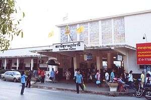 Surat Thani Railway Station, Phunphin District | |
 District location in Surat Thani Province | |
| Coordinates: 9°6′35″N 99°13′55″E | |
| Country | Thailand |
| Province | Surat Thani |
| Seat | Tha Kham |
| Area | |
| • Total | 1,208.7 km2 (466.7 sq mi) |
| Population (2014) | |
| • Total | 73,067 |
| • Density | 72.8/km2 (189/sq mi) |
| Time zone | UTC+7 (ICT) |
| Postal code | 84130 |
| Geocode | 8417 |
Geography
Neighboring districts are (from north clockwise): Tha Chang, Bandon, Ban Na Doem, Khian Sa, Khiri Rat Nikhom, and Vibhavadi. It has a short coastline on Bandon Bay to the northeast.
The main rivers of the district are the Tapi and its tributary Phum Duang, which flows into the Tapi at the town of Tha Kham.
History
The district's name was changed from Tha Kham to Phunphin in 1939.[2]
Administration
Central administration
Phunphin District is divided into 16 sub-districts (tambons), which are further subdivided into 98 administrative villages (mubans).
|
 |
Local administration
There is one town (thesaban mueang) in the district:
- Tha Kham (Thai: เทศบาลเมืองท่าข้าม) consisting of parts of sub-district Tha Kham.
There are 16 sub-district administrative organizations (SAO) in the district:
- Tha Kham (Thai: องค์การบริหารส่วนตำบลท่าข้าม) consisting of parts of sub-district Tha Kham.
- Tha Sathon (Thai: องค์การบริหารส่วนตำบลท่าสะท้อน) consisting of sub-district Tha Sathon.
- Lilet (Thai: องค์การบริหารส่วนตำบลลีเล็ด) consisting of sub-district Lilet.
- Bang Maduea (Thai: องค์การบริหารส่วนตำบลบางมะเดื่อ) consisting of sub-district Bang Maduea.
- Bang Duean (Thai: องค์การบริหารส่วนตำบลบางเดือน) consisting of sub-district Bang Duean.
- Tha Rong Chang (Thai: องค์การบริหารส่วนตำบลท่าโรงช้าง) consisting of sub-district Tha Rong Chang.
- Krut (Thai: องค์การบริหารส่วนตำบลกรูด) consisting of sub-district Krut.
- Phunphin (Thai: องค์การบริหารส่วนตำบลพุนพิน) consisting of sub-district Phunphin.
- Bang Ngon (Thai: องค์การบริหารส่วนตำบลบางงอน) consisting of sub-district Bang Ngon.
- Si Wichai (Thai: องค์การบริหารส่วนตำบลศรีวิชัย) consisting of sub-district Si Wichai.
- Nam Rop (Thai: องค์การบริหารส่วนตำบลน้ำรอบ) consisting of sub-district Nam Rop.
- Maluan (Thai: องค์การบริหารส่วนตำบลมะลวน) consisting of sub-district Maluan.
- Hua Toei (Thai: องค์การบริหารส่วนตำบลหัวเตย) consisting of sub-district Hua Toei.
- Nong Sai (Thai: องค์การบริหารส่วนตำบลหนองไทร) consisting of sub-district Nong Sai.
- Khao Hua Khwai (Thai: องค์การบริหารส่วนตำบลเขาหัวควาย) consisting of sub-district Khao Hua Khwai.
- Tapan (Thai: องค์การบริหารส่วนตำบลตะปาน) consisting of sub-district Tapan.
Transport
Phunphin is the transportation hub of Surat Thani Province. It has one railway intersection, three railway stations, and four rail stops. Surat Thani Railway Station in this district is the main passenger railway station of Surat Thani Province. At the Ban Thung Pho junction (km631) the southern railway branches to what was originally intended to connect the railway to Takua Thung District, Phang Nga, just north of Phuket Province. After the completion of 31 km of the railroad to Khiri Ratthanikhom in 1956, construction was halted for budgetary reasons.
Also in Phunphin are the Surat Thani Airport, the Inland Container Depot (ICD), and the Asian highway AH2 (Thai Hwy 41), the main road connecting to other provinces. Thai Hwy 401 connects Phunphin with the town of Surat Thani.
References
- "Surat Thani". Department of Provincial Administration (DOPA). Retrieved 28 August 2016.
- พระราชกฤษฎีกาเปลี่ยนนามอำเภอ กิ่งอำเภอ และตำบลบางแห่ง พุทธศักราช ๒๔๘๒ (PDF). Royal Gazette (in Thai). 56 (0 ก): 354–364. April 17, 1939.
- "Population statistics 2014" (in Thai). Department of Provincial Administration. Retrieved 2015-02-08.
External links

- amphoe.com (Thai)