Khian Sa District
Khian Sa (Thai: เคียนซา, pronounced [kʰīa̯n sāː]) is a district (amphoe) in Surat Thani Province, Thailand.
Khian Sa เคียนซา | |
|---|---|
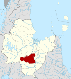 District location in Surat Thani Province | |
| Coordinates: 8°50′27″N 99°11′39″E | |
| Country | Thailand |
| Province | Surat Thani |
| Seat | Khian Sa |
| Area | |
| • Total | 583.6 km2 (225.3 sq mi) |
| Population (2005) | |
| • Total | 42,619 |
| • Density | 73.03/km2 (189.1/sq mi) |
| Time zone | UTC+7 (ICT) |
| Postal code | 84260 |
| Geocode | 8414 |
Neighboring districts are (from the north clockwise) Khiri Rat Nikhom, Phunphin, Ban Na Doem, Ban Na San, Wiang Sa, Phrasaeng and Phanom. Khian Sa is about 60 kilometres from Surat Thani.
Geography
The district is in the Khian Sa basin, which is crossed by the Tapi River, which also forms part of the eastern boundary of the district. The area of the district is mostly used for palm farming or rubber plantations, while along the river are swamps like the Nong Thung Thong swamp.
The main road through the district is Thailand Route 44, which connects Krabi with Khanom.
History
The district was formed as a minor district (king amphoe) on 15 December 1970, splitting the two tambons Khian Sa and Phuang Phromkhon from Ban Na San District.[1] On 1 April 1974 it was elevated to full district status.[2]
Administration

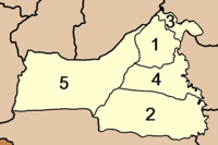
The district is divided into five sub-districts (tambons), which in turn are further subdivided into 52 villages (mubans). Khian Sa has township status (thesaban tambon), covering parts of tambon Khian Sa. Each of the tambons is administered by a tambon administrative office (TAO).
|
 |
References
- ประกาศกระทรวงมหาดไทย เรื่อง แบ่งท้องที่ตั้งเป็นกิ่งอำเภอ กิ่งอำเภอเคียนซา (PDF). Royal Gazette (in Thai). 87 (116 ง): 3512. 15 December 1970.
- พระราชกฤษฎีกาตั้งอำเภอเขาวง อำเภอเชียงม่วน อำเภอดอนตาล อำเภอชาติตระการ อำเภอภูเรือ อำเภอเคียนซา อำเภอน้ำโสม อำเภอหนองวัวซอ และอำเภอน้ำยืน พ.ศ. ๒๕๑๗ (PDF). Royal Gazette (in Thai). 91 (54 ก special issue): 30–33. 28 Mar 1974.
External links
- amphoe.com
- Khian Sa police station (Thai only)