Phra Phutthabat District
Phra Phutthabat (Thai: พระพุทธบาท) is a district (amphoe) in Saraburi Province, Thailand.
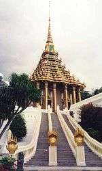
Wat Phra Buddha Baat
Phra Phutthabat พระพุทธบาท | |
|---|---|
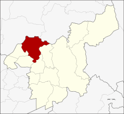 District location in Saraburi Province | |
| Coordinates: 14°43′32″N 100°47′43″E | |
| Country | Thailand |
| Province | Saraburi |
| Seat | Phra Phutthabat |
| Area | |
| • Total | 287.1 km2 (110.8 sq mi) |
| Population (2000) | |
| • Total | 70.354 |
| • Density | 0.25/km2 (0.63/sq mi) |
| Time zone | UTC+7 (ICT) |
| Postal code | 18120 |
| Geocode | 1909 |
The district is named after the Phra Phutthabat Temple. Another well-known temple in the district is Wat Tham Krabok, both as a Hmong refugee camp and as for its drug rehabilitation program.
Geography
Neighboring districts are (clockwise from the north): Mueang Lopburi and Phatthana Nikhom of Lopburi Province; and Chaloem Phra Kiat, Sao Hai, Ban Mo, Nong Don.
Administration
Phra Phuttabat is divided into nine sub-districts (tambons), which are further divided into 67 villages (mubans).
| No. | Name | Thai name |
|---|---|---|
| 1. | Phra Phutthabat | พระพุทธบาท |
| 2. | Khun Khlon | ขุนโขลน |
| 3. | Than Kasem | ธารเกษม |
| 4. | Na Yao | นายาว |
| 5. | Phu Kham Chan | พุคำจาน |
| No. | Name | Thai name |
|---|---|---|
| 6. | Khao Wong | เขาวง |
| 7. | Huai Pa Wai | ห้วยป่าหวาย |
| 8. | Phu Krang | พุกร่าง |
| 9. | Nong Kae | หนองแก |
gollark: This is not actually working for me.
gollark: 3.85kRelated.
gollark: I agree.
gollark: https://images-ext-2.discordapp.net/external/bTwfpc26DYSllq58ZO5T0b23QBtM5Shmnjga0z2hKig/https/media.discordapp.net/attachments/487976605340139521/960852541862723624/3FD4ED2A-17DD-40E7-980C-A37BEB6E9DC9.png
gollark: Due to inevitable loss of bees to accidents we may lose all bees by 2024 or later or earlier.
This article is issued from Wikipedia. The text is licensed under Creative Commons - Attribution - Sharealike. Additional terms may apply for the media files.