Kaeng Khoi District
Kaeng Khoi (Thai: แก่งคอย, pronounced [kɛ̀ŋ kʰɔ̄ːj]) is a district (amphoe) in the northeastern part of Saraburi Province, central Thailand, regarded as the largest district of the province.
Kaeng Khoi แก่งคอย | |
|---|---|
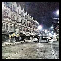
 Kaeng Khoi at nightfall | |
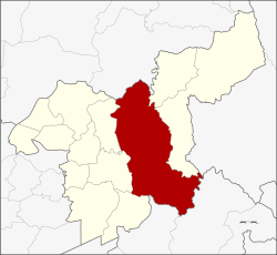
 District location in Saraburi Province | |
| Coordinates: 14°35′11″N 100°59′52″E | |
| Country | Thailand |
| Province | Saraburi |
| Seat | Kaeng Khoi |
| Area | |
| • Total | 801.1 km2 (309.3 sq mi) |
| Population (2005) | |
| • Total | 88,921 |
| • Density | 110/km2 (290/sq mi) |
| Time zone | UTC+7 (ICT) |
| Postal code | 18110 |
| Geocode | 1902 |
History
The district was created in 1827 and called khwaeng Kaeng Khoi. The district office was in Ban Tan Diao. In 1897, the khwaeng was converted to an amphoe. The office of the district was moved from the Pa Sak River bank to the nearby Kaeng Khoi Railway Station in 1915.
Its name Kaeng Khoi distorted from Raeng Khoi (แร้งคอย), directly translated as 'vulture waiting'. Because the district in the past was the gateway to Dong Phaya Fai (ดงพญาไฟ) or presently Dong Phaya Yen. The large rain forest was full of wildlife and malaria. Many people died while traveling here, so often the vultures gathered to wait to eat the corpses.[1]
Geography
Neighbouring districts are (from the north clockwise) Phatthana Nikhom of Lopburi Province, Wang Muang and Muak Lek of Saraburi Province, Mueang Nakhon Nayok and Ban Na of Nakhon Nayok Province, Wihan Daeng, Mueang Saraburi, and Chaloem Phra Kiat of Saraburi.
The district marks the western end of Khao Yai National Park. In the southern part of the district is the Chet Khot-Pong Kon Sao Nature Study Centre, containing several waterfalls.
Administration
The district is divided into 14 sub-districts (tambons), which are further subdivided into 116 villages (mubans). Kaeng Khoi is a town (thesaban mueang) and Thap Kwang a sub-district municipality (thesaban tambon), both covering the same-named tambons. There are 12 tambon administrative organizations (TAO) in the district.
| No. | Name | Thai name | Villages | Pop. |
|---|---|---|---|---|
| 1. | Kaeng Khoi | แก่งคอย | - | 11,921 |
| 2. | Thap Kwang | ทับกวาง | 10 | 14,991 |
| 3. | Tan Diao | ตาลเดี่ยว | 11 | 9,487 |
| 4. | Huai Haeng | ห้วยแห้ง | 12 | 6,947 |
| 5. | Tha Khlo | ท่าคล้อ | 11 | 4,619 |
| 6. | Hin Son | หินซ้อน | 9 | 3,535 |
| 7. | Ban That | บ้านธาตุ | 5 | 1,807 |
| 8. | Ban Pa | บ้านป่า | 10 | 9,028 |
| 9. | Tha Tum | ท่าตูม | 4 | 2,130 |
| 10. | Cha-om | ชะอม | 11 | 6,891 |
| 11. | Song Khon | สองคอน | 11 | 6,180 |
| 12. | Tao Pun | เตาปูน | 7 | 2,029 |
| 13. | Cham Phak Phaeo | ชำผักแพว | 10 | 5,849 |
| 15. | Tha Maprang | ท่ามะปราง | 5 | 3,507 |
Geocode 14 is not used.
Transportation
Kaeng Khoi Junction Railway Station is the main railway station of the district, considered as junction station of four railway lines (two northeastern lines and one eastern line). It is located 125.106 km (77.7 mi) from Bangkok Railway Station (Hua Lamphong).
In addition, this station is also of historical significance. As it was used as a part of the transport of government troops from Bangkok to suppress the Boworadet rebellion during October 1933.[2]
References
- Sompop Chaokhao (2010-04-03). "เมืองแก่งคอย ย้อนรอยสงครามโลก" [Kaeng Khoi town retracing World War]. Bloggang (in Thai).
- Tri (2010-12-10). "ย้อนรอย สงครามกลางเมืองครั้งแรกของคนไทยปกป้องรัฐธรรมนูญ 2475 (กบฏบวรเดช)" [Retrace to the Thai people's first civil war for protecting the 1932 constitution (Boworadet rebellion)]. Oknation (in Thai). Retrieved 2020-04-22.