Peters River
The Peters River is a river in the U.S. states of Massachusetts and Rhode Island.[1] It flows 7.0 miles (11.3 km).[2]

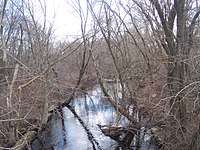
The Peters River at the Diamond Hill Road (RI 114) crossing in Woonsocket, Rhode Island.
Course
The river rises from Curtis Pond in Bellingham, Massachusetts, flowing south through Bellingham and into Woonsocket, Rhode Island where is flows into the Blackstone River.
Crossings
Below is a list of all crossings over the Peters River. The list starts at the headwaters and goes downstream.
- Bellingham
- Maple Brook Road
- Cross Street
- Railroad Street
- Pulaski Boulevard
- Wrentham Road
- Paine Street
- Woonsocket
- Diamond Hill Road (RI 114)
- Wood Avenue
- Mill Street
Tributaries
Arnolds and Bungay Brooks are the only two named tributaries of the Peters River, though it has many unnamed streams that also feed it.
gollark: Vaguely relatedly, if anyone knows what's going on with the websockets, tell me or else before I have to try and figure out how to work wireshark.
gollark: Ah, so it's DOUBLE infinite, good job me.
gollark: <@319753218592866315> How'd I fail at making it, exactly?
gollark: The only serverside logic is the bit where it redirects anything after /infipage to /infipage internally.
gollark: It's basically all in the browser.
See also
- List of rivers in Massachusetts
- List of rivers in Rhode Island
- Blackstone River
References
- U.S. Geological Survey Geographic Names Information System: Peters River
- U.S. Geological Survey. National Hydrography Dataset high-resolution flowline data. The National Map, accessed April 1, 2011
This article is issued from Wikipedia. The text is licensed under Creative Commons - Attribution - Sharealike. Additional terms may apply for the media files.