Cole River
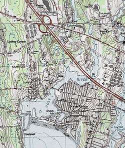
The Cole River is located in Bristol County, Massachusetts. It flows 11.8 miles (19.0 km)[1] from its headwaters in Dighton, Massachusetts through the towns of Rehoboth and Swansea into Mount Hope Bay, an arm of Narragansett Bay. The Cole River becomes tidal after crossing under the G.A.R. Highway (U.S. Route 6) in Swansea.[2]

Map of Cole River showing the tidal portion near the village of Ocean Grove
View of Cole River from Ocean Grove
Named tributaries
- Cole Brook (from Rehoboth, Massachusetts)
Crossings
- Wellington Street
- Cedar Street
- Lewis Street
- Baker Street
- Hortonville Road
- Wood Street
- Milford Street
- G.A.R. Highway (U.S. Route 6)
- Interstate 195
- Route 103
gollark: Which is probably unnecessary and results in security issues and bigger datas.
gollark: You can include some kind of JSON schema (because there are lots of things for that) with the docs. Though presumably someone will notice if the API is missing a field they need.
gollark: Your API should have documentation. Just use that.
gollark: The best format for data exchange between APIs is of course small SQLite databases.
gollark: You really should not be bundling your schema *with your data*.
See also
- Coles Brook, a short stream in nearby Seekonk, Massachusetts
- Ocean Grove, Massachusetts
References
- U.S. Geological Survey. National Hydrography Dataset high-resolution flowline data. The National Map Archived 2016-06-30 at the Wayback Machine, accessed April 1, 2011
- USGS Quadrangle Maps
This article is issued from Wikipedia. The text is licensed under Creative Commons - Attribution - Sharealike. Additional terms may apply for the media files.