Perryville, Maryland
Perryville is a town in Cecil County, Maryland, United States. The population was 4,361 at the 2010 census. The town is located near an access for Interstate 95, on the north side of the outlet of the Susquehanna River.
Perryville, Maryland | |
|---|---|
U.S. Post Office, Perryville MD, April 2010 | |
 Seal | |
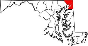
 Location of Perryville, Maryland | |
| Coordinates: 39°34′11″N 76°4′7″W | |
| Country | |
| State | |
| County | |
| Incorporated | 1882[1] |
| Government | |
| • Mayor | Robert R Ashby Jr. |
| Area | |
| • Total | 2.97 sq mi (7.70 km2) |
| • Land | 2.96 sq mi (7.68 km2) |
| • Water | 0.01 sq mi (0.02 km2) |
| Elevation | 72 ft (22 m) |
| Population | |
| • Total | 4,361 |
| • Estimate (2019)[4] | 4,419 |
| • Density | 1,490.39/sq mi (575.42/km2) |
| Time zone | UTC−5 (Eastern (EST)) |
| • Summer (DST) | UTC−4 (EDT) |
| ZIP code | 21903 |
| Area code(s) | 410 |
| FIPS code | 24-61150 |
| GNIS feature ID | 0590999 |
| Website | http://www.perryvillemd.org/ |
History
Perryville was first settled during 1622 when Edward Palmer was granted a patent for a settlement on what is now Garrett Island. During the 17th century, Lord Baltimore granted George Talbot 31,000 acres (130 km2) of land which included the Perryville area. Before incorporation (1882), the settlement was known as Lower Ferry (circa 1695), Susquehanna (circa 18th century), and was finally named Perryville after Mary Perry, the wife of John Bateman.
During the Revolutionary War, Perryville served as a staging area for the Continental Army. Colonel John Rodgers (1728–1791), who operated the ferry and tavern in Perryville, raised the 5th Company of the Maryland Militia. This company became part of the famous Flying Camp and was instrumental during the early stages of the Revolutionary War. George Washington stopped frequently at Rodgers Tavern on his travels from Virginia to New York. Rodgers Tavern was listed on the National Register of Historic Places during 1972.[5] Colonel Rodgers' son, John Rodgers, was instrumental in suppressing the Tripolitan pirates in the Mediterranean Sea and was subsequently promoted to Commodore of the Mediterranean Squadron. Commodore Rodgers served with distinction during the War of 1812 and is known as the "Father of the American Navy."
During the 19th century, Perryville was the midway station for the Wilmington to Baltimore Rail Line. During the American Civil War, the railway line between Perryville and Baltimore was destroyed. To transport troops and munitions to Annapolis, the Union Army again began the operation of the ferry across the Susquehanna. The Principio Furnace is located nearby and was listed on the National Register of Historic Places in 1972.[5]
During the 20th century, it was an important destination for those going to the U. S. Naval Training Station at Bainbridge, Maryland, about three miles up the road, now no longer functioning and sold by the Navy. (See "United States Naval Training Center, Bainbridge") Perryville continued to serve as a railroad town. The interstate highway system, with access near Perryville, brought business from highway travelers.
Perryville is currently home to the Perry Point Veteran's Medical Center, located on a picturesque campus at the outlet of the Susquehanna River into Chesapeake Bay. This same location is also the Northeast Campus of AmeriCorps National Civilian Community Corps, a residential national service program which recruits young Americans between the ages of 18 to 24 to perform community service in various locations in the country.
Perryville is the northern terminus of the MARC Penn Line commuter rail service, which runs south to Washington, D.C. via Baltimore. The 1905-built station also serves as a railroad museum and an Amtrak maintenance facility.
Perryville is home to the largest linwood tree in Maryland, located at 50 Millcreek Road on an estate known formerly as the Anchorage. Perryville is also home to numerous historical sites including the Principio Furnace.
Geography
Perryville is located at 39°34′11″N 76°4′7″W (39.569662, −76.068725).[6]
According to the United States Census Bureau, the town has a total area of 3.06 square miles (7.93 km2), of which 3.05 square miles (7.90 km2) is land and 0.01 square miles (0.03 km2) is water.[7]
Demographics
| Historical population | |||
|---|---|---|---|
| Census | Pop. | %± | |
| 1880 | 143 | — | |
| 1890 | 344 | 140.6% | |
| 1900 | 770 | 123.8% | |
| 1910 | 635 | −17.5% | |
| 1920 | 652 | 2.7% | |
| 1930 | 704 | 8.0% | |
| 1940 | 729 | 3.6% | |
| 1950 | 679 | −6.9% | |
| 1960 | 674 | −0.7% | |
| 1970 | 2,091 | 210.2% | |
| 1980 | 2,018 | −3.5% | |
| 1990 | 2,456 | 21.7% | |
| 2000 | 3,672 | 49.5% | |
| 2010 | 4,361 | 18.8% | |
| Est. 2019 | 4,419 | [4] | 1.3% |
| U.S. Decennial Census[8] | |||
2010 census
As of the census[3] of 2010, there were 4,361 people, 1,762 households, and 1,130 families living in the town. The population density was 1,429.8 inhabitants per square mile (552.0/km2). There were 1,959 housing units at an average density of 642.3 per square mile (248.0/km2). The racial makeup of the town was 84.6% White, 9.6% African American, 0.4% Native American, 1.3% Asian, 0.1% Pacific Islander, 1.0% from other races, and 2.9% from two or more races. Hispanic or Latino of any race were 4.2% of the population.
There were 1,762 households of which 32.2% had children under the age of 18 living with them, 48.0% were married couples living together, 11.9% had a female householder with no husband present, 4.3% had a male householder with no wife present, and 35.9% were non-families. 30.6% of all households were made up of individuals and 11.5% had someone living alone who was 65 years of age or older. The average household size was 2.46 and the average family size was 3.07.
The median age in the town was 40.7 years. 23.4% of residents were under the age of 18; 7.9% were between the ages of 18 and 24; 25.1% were from 25 to 44; 30.9% were from 45 to 64; and 12.6% were 65 years of age or older. The gender makeup of the town was 49.7% male and 50.3% female.

2000 census
As of the census[9] of 2000, there were 3,672 people, 1,443 households, and 988 families living in the town. The population density was 1,479.0 people per square mile (571.7/km2). There were 1,507 housing units at an average density of 607.0 per square mile (234.6/km2). The racial makeup of the town was 90.93% Caucasian, 5.86% African American, 0.27% Native American, 0.76% Asian, 0.54% from other races, and 1.63% from two or more races. Hispanic or Latino of any race were 2.31% of the population.
There were 1,443 households out of which 35.1% had children under the age of 18 living with them, 51.6% were married couples living together, 11.9% had a female householder with no husband present, and 31.5% were non-families. 27.3% of all households were made up of individuals and 10.8% had someone living alone who was 65 years of age or older. The average household size was 2.52 and the average family size was 3.05.
In the town, the population was spread out agewise with 27.2% under the age of 18, 6.4% from 18 to 24, 32.5% from 25 to 44, 22.9% from 45 to 64, and 11.0% who were 65 years of age or older. The median age was 36 years. For every 100 females, there were 94.6 males. For every 100 females age 18 and over, there were 93.0 males.
The median income for a household in the town was $43,984, and the median income for a family was $52,981. Males had a median income of $39,112 versus $28,526 for females. The per capita income for the town was $20,040. About 6.0% of families and 7.8% of the population were below the poverty line, including 5.8% of those under age 18 and 21.8% of those age 65 or over.
Economy
The town is home to one of IKEA's distribution centers, which houses one of the largest rooftop solar arrays in the U.S., and the largest in the state of Maryland.[10] The distribution center’s total 4.9-MW solar installation of 25,913 panels generates 6,092,533 kWh of clean electricity yearly.
In 2010 Perryville opened the first legal casino in Maryland (Hollywood Casino Perryville). The casino is near the southbound exit of I-95. It offers slot machines, video gaming, table games, and a poker room area. The revenues from the casino are divided with the Town of Perryville and Cecil County government as well as the state.
In 2018, it was announced that Great Wolf Resorts would open a new Great Wolf Lodge in Perryville.
Library

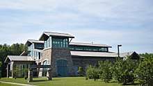
A new Perryville Branch of the Cecil County Public Library was opened in 2008.
Schools
There are four schools within Perryville's limits. Perryville Elementary, Middle and High Schools are public. The school sports mascot of Perryville High School is the panther. There is also one private school, a Catholic K-8 school named Good Shepherd. It is affiliated with the Roman Catholic Church of the same name.
Churches
The following are the six churches in Perryville: Blythedale Seventh-day Adventist Church, First Baptist Church of Perryville, Good Shepherd Catholic Church, Perryville Presbyterian Church, Perryville United Methodist Church, and St. Mark's Episcopal Church.[11]
References
- "Perryville". Maryland Manual. Retrieved 25 June 2017.
- "2019 U.S. Gazetteer Files". United States Census Bureau. Retrieved July 25, 2020.
- "U.S. Census website". United States Census Bureau. Retrieved 2013-01-25.
- "Population and Housing Unit Estimates". United States Census Bureau. May 24, 2020. Retrieved May 27, 2020.
- "National Register Information System". National Register of Historic Places. National Park Service. April 15, 2008.
- "US Gazetteer files: 2010, 2000, and 1990". United States Census Bureau. 2011-02-12. Retrieved 2011-04-23.
- "US Gazetteer files 2010". United States Census Bureau. Archived from the original on 2012-01-25. Retrieved 2013-01-25.
- "Census of Population and Housing". Census.gov. Retrieved June 4, 2015.
- "U.S. Census website". United States Census Bureau. Retrieved 2008-01-31.
- "IKEA Completes Near-Doubling of Maryland's Largest Rooftop Array, on Distribution Center in Perryville, Making It One of the Largest Such Installations in the U.S."
- "Perryville Churches". Archived from the original on 2011-10-06. Retrieved 2011-10-25.
External links
| Wikimedia Commons has media related to Perryville, Maryland. |
