Percy Main
Percy Main is a small village absorbed into North Shields, North East England. Historically in Northumberland, it is now part of Tyne and Wear.
History
It is named after the colliery belonging to the Percy family, which was located just south of the railway, near St. John's church. The colliery was sunk in 1799 & went to a depth of 247 metres to the renowned Main seam, which was considered the best coal for household use. The village grew up around it to serve the pit, which eventually closed in 1895. In 1872, the population was recorded as 3,953, residing in 786 houses. The inhabitants worked mainly in the neighbouring docks and other industries.[1]
During World War II, children from the village were evacuated to Hexham, Northumberland.
Recreation
Sport
Sport is popular in the village, with Percy Main Cricket Club playing at St John's Green in the Northumberland and Tyneside Senior Cricket League, with their next door neighbours Percy Main Amateurs F.C. playing at Purvis Park in the Northern Football Alliance Premier Division. A hedge separates the two teams.[2]
Transport
The village's main and only modern-day railway station is the Percy Main Metro station.
The original footbridge from the station is preserved at the National Railway Museum, York. A passenger station opened on the Newcastle and North Shields Railway around 1840.[3] It closed on 11 August 1980 to allow conversion for the Metro, before re-opening on 14 November 1982.[4]
Religion
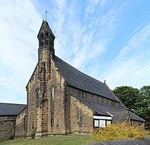
St John's Church was built for the Duke of Northumberland in 1862, and is grade II listed.[5] Designed by Anthony Salvin, it is built in sandstone and was re-ordered around 2000, to incorporate use as a community centre.[6] Located on St John's Terrace, the church shares a vicar with the nearby St Peter's, on the Balkwell estate.[7]
The Diocese of Newcastle's main administrative office and resource centre are located at Church House, formerly Percy St John's Primary School.[8]
The village, at one time, also had primitive Methodist and Baptist chapels, though these no longer exist.[9]
Education
Percy Main Primary School is located in the village.[10] Norham High School, providing secondary education, is located a little to the north.
Geography
The village is around a mile and a half south west of the centre of North Shields. The hamlet of East Howdon is almost immediately south.
.jpg)
The large Meadow Well estate borders the village to the north. The portion of the estate south of the Metro line, and to the east of Percy Main, was redeveloped as Riverside Park in the early 1990s.
The Royal Quays Outlet Centre and Northumbrian Water's treatment works lie between the village and the River Tyne.
References
- "History of Percy Main, in North Tyneside and Northumberland | Map and description". www.visionofbritain.org.uk. Retrieved 2019-07-30.
- "Percy Main CC". percymain.play-cricket.com. Retrieved 2017-05-14.
- "Disused Stations: Percy Main Station". www.disused-stations.org.uk. Retrieved 2019-07-30.
- "Percy Main Metro station : Tyne and Wear Metro : TheTrams.co.uk". www.thetrams.co.uk. Retrieved 2019-07-30.
- "Church of St. John the Evangelist, Percy Main | Co-Curate". co-curate.ncl.ac.uk. Retrieved 2019-07-30.
- Historic England. "CHURCH OF ST JOHN THE EVANGELIST, North Tyneside (1355013)". National Heritage List for England. Retrieved 2019-07-30.
- "St John Percy - A Church Near You". www.achurchnearyou.com. Retrieved 2019-07-30.
- "Diocese of Newcastle | Church House". www.newcastle.anglican.org. Archived from the original on 2016-11-06. Retrieved 2017-05-14.
- "Percy Main, St. John's Street, Wesleyan Methodist Church | sitelines.newcastle.gov.uk". twsitelines.info. Retrieved 2019-07-30.
- Interactive, Enigma. "Percy Main Primary School | Percy Main | North Shields | North Tyneside". www.percymainprimary.org.uk. Retrieved 2017-05-14.
- Lawrence, Danny. Shiels to Shields, The History of a Tyneside Town. 2016