Pen Mar, Pennsylvania
Pen Mar is an unincorporated community and census-designated place (CDP) in Washington Township, Franklin County, Pennsylvania, United States. It is located along the Mason–Dixon line, bordered to the south by the community of Pen Mar Park in Maryland. As of the 2010 census the population of Pen Mar was 929.[1]
Pen Mar, Pennsylvania | |
|---|---|
 Pen Mar  Pen Mar | |
| Coordinates: 39°43′14″N 77°30′24″W | |
| Country | United States |
| State | Pennsylvania |
| County | Franklin |
| Township | Washington |
| Area | |
| • Total | 0.75 sq mi (1.93 km2) |
| • Land | 0.74 sq mi (1.91 km2) |
| • Water | 0.008 sq mi (0.02 km2) |
| Elevation | 1,246 ft (380 m) |
| Population (2010) | |
| • Total | 929 |
| • Density | 1,258/sq mi (485.6/km2) |
| Time zone | UTC-5 (Eastern (EST)) |
| • Summer (DST) | UTC-4 (EDT) |
| ZIP code | 17268 |
| FIPS code | 42-58776 |
| GNIS feature ID | 2634268 |
Geography
Pen Mar is located in southeastern Franklin County, Pennsylvania, on the western slope of South Mountain. Pennsylvania Route 550 is the main road through the community, leading northwest down the mountain 2 miles (3 km) to Rouzerville. Waynesboro, Pennsylvania, is 4.5 miles (7.2 km) northwest of Pen Mar, and the site of the former Fort Ritchie in Maryland is 1 mile (1.6 km) to the southeast.
gollark: Big ones seem annoyingly expensive though.
gollark: You can get a few small e-papery displays for Raspberry Pis and whatnot.
gollark: I would prefer something more lightweight anyway for battery life.
gollark: The tweet was asking about RTOSes.
gollark: <@540815739884404736> I don't think it'll run Linux.
References
- "Geographic Identifiers: 2010 Census Summary File 1 (G001), Pen Mar CDP, Pennsylvania". American FactFinder. U.S. Census Bureau. Archived from the original on February 13, 2020. Retrieved August 12, 2016.
External links
Municipalities and communities of Franklin County, Pennsylvania, United States | ||
|---|---|---|
| Boroughs | 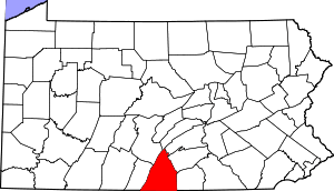 | |
| Townships | ||
| CDPs | ||
| Unincorporated communities |
| |
| Footnotes | ‡This populated place also has portions in an adjacent county or counties | |
This article is issued from Wikipedia. The text is licensed under Creative Commons - Attribution - Sharealike. Additional terms may apply for the media files.