Payne Township, Gove County, Kansas
Payne Township is a township in Gove County, Kansas, USA. As of the 2000 census, its population was 315.
Payne Township | |
|---|---|
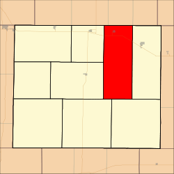 Location in Gove County | |
| Coordinates: 38°59′45″N 100°20′36″W | |
| Country | United States |
| State | Kansas |
| County | Gove |
| Area | |
| • Total | 125.06 sq mi (323.9 km2) |
| • Land | 125.06 sq mi (323.89 km2) |
| • Water | 0 sq mi (0.01 km2) 0% |
| Elevation | 2,694 ft (821 m) |
| Population (2000) | |
| • Total | 315 |
| • Density | 2.5/sq mi (1/km2) |
| GNIS feature ID | 0471317 |
Geography
Payne Township covers an area of 125.06 square miles (323.9 km2) and contains one incorporated settlement, Park. According to the USGS, it contains one cemetery, Sacred Heart.
The streams of East Spring Creek and North Fork Big Creek run through this township.
Transportation
Payne Township contains one airport or landing strip, Ashbaugh Airport.
gollark: <@000000000000000000000000000> implement macron.
gollark: <@!766274162036572171> you.
gollark: ++apioform
gollark: ++apioform
gollark: Ideatic apioforms in meta-ubqvian space.
External links
Municipalities and communities of Gove County, Kansas, United States | ||
|---|---|---|
| Cities | 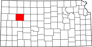 Map of Kansas highlighting Gove County | |
| Ghost towns | ||
| Townships | ||
| Footnotes | ‡This populated place also has portions in an adjacent county or counties | |
This article is issued from Wikipedia. The text is licensed under Creative Commons - Attribution - Sharealike. Additional terms may apply for the media files.