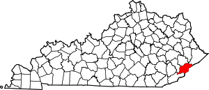
Payne Gap, Kentucky
Payne Gap is an unincorporated community and census-designated place in Letcher County, Kentucky, United States. Its population was 329 as of the 2010 census.[1] U.S. Route 119 passes through the community.
Payne Gap, Kentucky | |
|---|---|
 Payne Gap  Payne Gap | |
| Coordinates: 37°09′19″N 82°39′34″W | |
| Country | United States |
| State | Kentucky |
| County | Letcher |
| Area | |
| • Total | 2.306 sq mi (5.97 km2) |
| • Land | 2.305 sq mi (5.97 km2) |
| • Water | 0.001 sq mi (0.003 km2) |
| Elevation | 1,762 ft (537 m) |
| Population | |
| • Total | 329 |
| • Density | 140/sq mi (55/km2) |
| Time zone | UTC-5 (Eastern (EST)) |
| • Summer (DST) | UTC-4 (EDT) |
| Area code(s) | 606 |
| GNIS feature ID | 500292[2] |
Geography
According to the U.S. Census Bureau, the community has an area of 2.306 square miles (5.97 km2); 2.305 square miles (5.97 km2) of its area is land, and 0.001 square miles (0.0026 km2) is water.[1]
gollark: Email 1% of your money per day to GTech™ money intake 3.
gollark: It's short for G Technology.
gollark: We already recursively invest all money ever in GTech™. Very efficient.
gollark: Those are kind of cryo apio form.
gollark: Interesting investment strategy, if wrong.
References
- "2010 Census Gazetteer Files - Places: Kentucky". U.S. Census Bureau. Retrieved April 2, 2017.
- "Payne Gap". Geographic Names Information System. United States Geological Survey.
This article is issued from Wikipedia. The text is licensed under Creative Commons - Attribution - Sharealike. Additional terms may apply for the media files.
