Pathein District
Pathein District (Burmese: ပုသိမ်ခရိုင်) is a district of Ayeyawady Division, Myanmar. It is located around the city of Pathein and includes the urban area of it. The area of the Pathein District is 10899.8 km². Its population was 1,630,716 in 2014.[1]

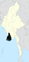
Map of Pathein District
Pathein District ပုသိမ်ခရိုင် | |
|---|---|
District of Ayeyarwady Division | |
 Pathein District | |
| Coordinates: 16°45′0″N 94°30′0″E | |
| Country | Myanmar |
| Division | Ayeyarwady |
| District | Pathein |
| Area | |
| • Total | 28,230 km2 (10,899.8 sq mi) |
| Population (2014) | |
| • Total | 1,630,716 |
| Time zone | UTC6:30 (MST) |
Townships
The district consists of the following townships:
- Pathein Township
- Kangyidaunk Township
- Thabaung Township
- Kyonpyaw Township
- Yekyi Township
- Kyaunggon Township
- Ngapudaw Township[2]
Towns
The district contains 9 towns:
It contains 48 wards, 519 village groups and 2963 villages.
gollark: Wow, the syntax highlighter really worked badly on my submission.
gollark: TOTALLY not mine.
gollark: i think it was for the wrong challenge.
gollark: #6 seems like it doesn't actually work.
gollark: LyricLy is LITERAL muonic lithium.
References
- Myanmar at GeoHive
- http://www.mrtv3.net.mm/newpaper/69newsn.pdf%5B%5D Page 10 Column 4
This article is issued from Wikipedia. The text is licensed under Creative Commons - Attribution - Sharealike. Additional terms may apply for the media files.