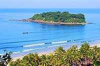
Ngwesaung
Ngwesaung (Burmese: ငွေဆောင် [ŋwè zàʊɰ̃]) is a beach resort located 48 km west of Pathein, Ayeyarwady Region, Myanmar. The beach is 5 hours drive, with no traffic, away from the principal city of Yangon, and an airport is in the works. Buses leave at 6am & 9:30pm from in front of the Yangon Central Railway Station. Opened in March 2000,[1] Ngwe Saung is newer than nearby and more popular Chaungtha Beach, and is designed to attract people with larger holiday budgets.[2][3][4]
Ngwesaung ငွေဆောင် | |
|---|---|
Village | |
| Ngwesaung | |
 | |
 Ngwesaung | |
| Coordinates: 16°51′30″N 94°23′30″E | |
| Country | |
| Division | |
| District | Pathein |
| Township | Pathein |
| Village | Ngwesaung |
| Settled | 2000[1] |
| Time zone | UTC6:30 (MST) |
Tourism
An unspoilt 15 kilometres (9.3 mi) stretch of silvery sand and modern amenities have made Ngwesaung a popular destination for less budget conscious tourists from Lower Myanmar. Still Ngwesaung has much to develop. Its choices for nightlife activities remain paltry, even by local standards. Chaungtha and Ngapali beaches have greater choices of nighttime activities. At this point, a nearby elephant training camp is a main daytime attraction at Ngwesaung.
The Calventuras Islands are a group of islets lying about 9 km to the west of Broken Point.[5]
References
| Wikivoyage has a travel guide for Ngwe Saung. |
- Pan Eiswe Star (16–22 November 2009). "Hoteliers make March plans for Ngwe Saung 10th anniversary". The Myanmar Times. Archived from the original on 25 November 2009.
- "Archived copy". Archived from the original on 29 August 2009. Retrieved 26 August 2009.CS1 maint: archived copy as title (link)
- "Archived copy". Archived from the original on 21 February 2009. Retrieved 26 August 2009.CS1 maint: archived copy as title (link)
- http://www.ngwesaung.org Archived 19 June 2013 at the Wayback Machine
- Prostar Sailing Directions 2005 India & Bay of Bengal. Enroute. National Geospatial-intelligence Agency (1 Feb 2007). p. 168