Palashipara
Palashipara, is a developed village of Nadia district, West Bengal, India.This village is located at right side Bank of the river Jalangi.This village is located under Palashipara PS and Tehatta II CD Block in Tehatta subdivision. There is also a Vidhan Sabha constituency named Palashipara (Vidhan Sabha constituency). Palashipara is the headquarters of Tehatta II Community Development Block and police station.[1]
Palashipara | |
|---|---|
Village | |
 Palashipara Location in West Bengal  Palashipara Palashipara (India) | |
| Coordinates: 23°47′0″N 88°27′0″E | |
| Country | |
| State | West Bengal |
| District | Nadia |
| Pin | 741155 |
History
At the time of the Battle of Plassey, their local people was migrated to a different place to avoid social and political turmoil and form a new human settlement. According to the etymology 'para' (locality) of the inhabitants of Palashi (Palashi) set up here. Palashipara is a very old village situated in the bank of Jalangi River. An indigo kuthi was established by the indigo planters at Nishchintapur village near Palashipara.[2] Before the Partition of Bengal (1947) this place was under Meherpur subdivision in British India.[3]
Demographics
As per the 2011 Census of India, Palashipara had a total population of 10,693, of which 5,434 (51%) were males and 5,259 (49%) were females. Population below 6 years was 955. The total number of literates in Palashipara was 7,911 (81.24% of the population over 6 years).[4]
CD Block HQ
The headquarters of Tehatta II CD Block are located at Palashipara.[5]
Education
There are two high schools at Palashipara. Palashipara Mahatma Gandhi Smriti Vidyapith known as MGS vidyapith is situated here. another Higher Secondary school Palashipara Mahatma Gandhi Smriti Balika Vidyalaya is the schools for girls', providing 10+2 education to the locals. There are few primary schools in the locality.[6]
Transport
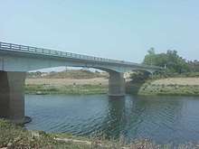
Palashipara is connected by bus with district headquarters Krishnagar. Nearest Plassey railway station at Plassey is almost 18 km from Palashipara. The connector of National Highway 34 (India) and State highway 11 passed through the village. A bridge named Dwijendralal Setu was made in 1971 over the Jalangi river in the way of the connector.[7][8]
References
- "Nadia Gets Its 22nd Police Station In Palashipara". Retrieved 17 December 2018.
- Lokesh Ch Biswas (2016). Tehatta Mahakumar Nilkuthi (Bengali). Chakdah: Monokothan, yearly little magazine. p. 8.
- Kumudnath Mullick (1998). Nadia Kahini (Bengali). Dhaka: Baipatra. p. 276. ISBN 978-984-8116-00-5.
- "2011 Census – Primary Census Abstract Data Tables". West Bengal – District-wise. Registrar General and Census Commissioner, India. Retrieved 18 May 2017.
- "District Census Handbook: Nadia, Series 20 Part XII A" (PDF). Map of Nadia with CD Block HQs and Police Stations (on the fourth page). Directorate of Census Operations, West Bengal, 2011. Retrieved 2 May 2017.
- "West Bengal Board of Secondary Education". wbbse.org. Retrieved 19 March 2017.
- "Top 30 analogous words or synonyms for patikabari". Retrieved 17 December 2018.
- "পলাশিপাড়ার সেতু". anandabazar.com. Retrieved 17 December 2018.
Cities, towns and locations in Nadia District | |||||||||
|---|---|---|---|---|---|---|---|---|---|
| Cities, municipal and census towns |
| ||||||||
| Locations other than cities and towns |
| ||||||||
| Related topics |
| ||||||||