Padgate
Padgate is a suburb of the English town and unitary authority of Warrington, Cheshire. It belongs to the civil parish of Poulton-with-Fearnhead.
| Padgate | |
|---|---|
 Christ Church | |
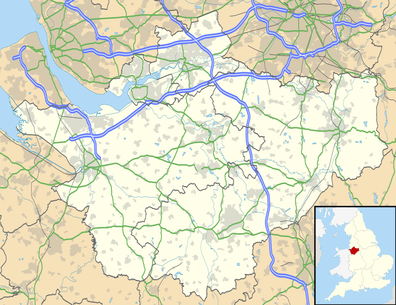 Padgate Location within Cheshire | |
| Civil parish | |
| Unitary authority | |
| Ceremonial county | |
| Region | |
| Country | England |
| Sovereign state | United Kingdom |
| Post town | WARRINGTON |
| Postcode district | WA1, WA2 |
| Dialling code | 01925 |
| UK Parliament | |
History
Overview
Historically part of Lancashire, and in the specific area of Warrington known as Poulton-with-Fearnhead. Up until 1838 Padgate as an area in its own right did not really exist. Up until then the land on which Padgate is now sited was part of farmland in the wider 'Poulton-with-Fearnhead' (or Fearnheid as it was then known) district, land belonging to Bruche Hall and so on. It was only with the establishment of an official parish (part of the Diocese of Chester, now in the Liverpool Diocese) and the building of Christ Church Padgate that a recognisable Padgate community arose. Up until that point the name 'Padgate' was used in local nomenclature for roads bridges etc. but with no recognisable central location which was called Padgate.
Following boundary changes enforced in 1974, Padgate, along with the rest of Warrington, came to reside in the county of Cheshire. It is now a largely residential, suburban district. Historically Padgate is most famous as the site of an R.A.F training camp and as the home of the former teacher training college known informally as 'Padgate College' which, despite its name, was actually situated in the neighbouring village of Fearnhead. Today the college is the Padgate Campus of the University of Chester.
Padgate has a number of features such as the railway station, three churches, a number of schools, a community centre and, next to the railway line, a large area of land and playing fields known as Bennett's Recreation Ground often referred to locally as 'Bennett's Rec'. This was the home of the Woolston Rovers rugby league side and also the Cheshire Cadets Drum and Bugle Corps (also known as Horizon Performing Arts) with their headquarters Kennedy Hall. Following a fire at the Rugby club house/bar, the club struggled to survive. Recently a new changing room facility has been built on the site of the former club house and the club is starting to rebuild. This is also home to Greenall's Padgate St Oswald's reserves football team who are currently competing in the Mid Cheshire Football League reserve division. Greenall's Padgate St Oswald's first team play at Tetley Walker's Club, Long Lane, Warrington.
What might be called the 'old' centre of Padgate (the area around the railway station, Christ Church, the Stocks public house (a new build from the 1960s which replaced a much older pub of the same name on the same site) and the community centre) is separated from what is the main commercial centre (known locally as 'Padgate shops') by Padgate Lane which connects the two - they lie approximately three quarters of a mile apart.
Padgate resides in the parliamentary constituency of Warrington North.
Geographically the area is situated on the east side of Warrington. It is north of the nearby River Mersey and is enclosed to the east by the M6 motorway. Topographically the land in the area is flat, being in the Mersey valley region (other than where man-made features such as the railway bridge have enforced changes).
Padgate Brook, a tributary of the Mersey, runs to the western edge of Padgate, it is in turn fed by numerous smaller waterways (Spittle Brook, Blackbrook, Spa Brook, Cinnamon Brook, Cross Brook, Cockshot Burn) originating in Peel Hall Meadows and other outlying rural stretches of land to the north of the district. To the east, Birchwood Brook also feeds the Mersey.
RAF Station
During the Second World War, Padgate had a small RAF Station. RAF Padgate will be well-remembered by thousands of young men who were selected for RAF national service and on this site received their first taste of military discipline, ill-fitting uniforms and a severe haircut.
The site of the former RAF station was demolished in the late 1990s, and since then the site has been largely covered by a Bellway housing estate, bordered by various other local amenities and suburbs of Warrington - Bennett's Rec (where the Cheshire Cadets Drum and Bugle Corps are based) and the railway line to the south, Fearnhead to the North-East, Blackbrook and Cinnamon Brow to the northern side. University Academy Warrington (a secondary school, originally known as Padgate High School and then renamed as Lysander Community High School) is also sited on this land.
The main entrance to the RAF camp was situated on what is now called Station Road North (re-named from its original Station Road title)
Although the RAF site is now largely invisible its legacy lives on in local place names and so on - Insall Road running east-west in parallel to the A574 is named after the one-time commanding officer of the site (Group Captain Insall), the local high school University Academy Warrington (originally named Padgate High School when it was opened in the late 1970s) was known from 2009 to 2013 as Lysander Community High School - the Westland Lysander being one of the aircraft linked to the former RAF base.
Remnants of the camp's presence can still be seen in some parts of the land for example the brickwork from the rifle range can still be seen close to the railway footbridge in the south-west corner of the former site.
University of Chester Padgate Campus
The university campus (which despite being known as 'the Padgate Campus' is in fact in the neighbouring village of Fearnhead) belonging to the University of Chester was used as a camp for Canadian servicemen during the Second World War. In 1946 it became a teacher training college and in the late 1960s was re-named to Padgate College of Education. In honour of the historical usage part of the site was named 'Canada Hall'.
The campus is now home to 384 students. A variety of degree courses are on offer, including degrees in journalism and sport-related subjects. The campus houses a SU bar named bar twenty ten. There are 8 halls of residence and also a cul-de-sac called College Close.
Geography
Located east of Warrington centre (4 kilometres (2.5 mi) far), Padgate lies in the middle of the urban areas of Liverpool and Manchester. It is 32 kilometres (20 mi) east of Liverpool, 44 kilometres (27 mi) west of Manchester, and 38 kilometres (24 mi) northeast of Chester.[1] The suburb is crossed to the south by the river Mersey and is not too far from the Manchester Ship Canal. A small tributary of the Mersey, the Padgate Brook, runs through Padgate in a roughly north-south trajectory, joining the Mersey in the Paddington area to the south.
Main sights
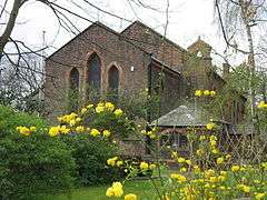
Its parish church, Christ Church (1838), is a listed building, the former rectory (built approximately 2 years later) associated with the church is locally listed. Christ Church has an affiliated Church of England Primary School nearby which also dates, in its present form, from around the same time. In 2016 work commenced on the building of a new vicarage in the grounds adjacent to the church. This new vicarage became the residence of the vicar in early 2017 and the old rectory is now a private residence.
There are two other churches in the area: Padgate Methodist Church and St. Oswalds Roman Catholic church.[2]
Transport
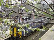
Padgate has an unmanned railway station on the Manchester-Liverpool line served by the local stopping service.[3] Up until the mid-1970s the station was fully manned and a row of cottages (still extant) next to the station were designed as residences for the station staff.
The M6 motorway is located some km east, and nearest exit is "Warrington-Irlam-A57". The A roads serving Padgate are the A50, A57 and A574.[1]
References
- 30431739 Padgate on OpenStreetMap
- "Padgate Chrish Church official website". Archived from the original on 6 January 2017. Retrieved 5 January 2017.
- 45020782 Padgate railway station on OpenStreetMap
External links
![]()