Oxford Township, Coshocton County, Ohio
Oxford Township is one of the twenty-two townships of Coshocton County, Ohio, United States. The 2010 census reported 1,527 people living in the township.[3]
Oxford Township, Coshocton County, Ohio | |
|---|---|
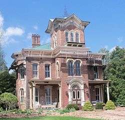 Shady Bend Manor (1874) on County Road 9 | |
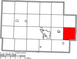 Location of Oxford Township in Coshocton County | |
| Coordinates: 40°15′52″N 81°40′4″W | |
| Country | United States |
| State | Ohio |
| County | Coshocton |
| Area | |
| • Total | 25.8 sq mi (66.8 km2) |
| • Land | 25.3 sq mi (65.4 km2) |
| • Water | 0.5 sq mi (1.4 km2) |
| Elevation | 801 ft (244 m) |
| Population (2010) | |
| • Total | 1,527 |
| • Density | 61/sq mi (23.4/km2) |
| Time zone | UTC-5 (Eastern (EST)) |
| • Summer (DST) | UTC-4 (EDT) |
| FIPS code | 39-59248[2] |
| GNIS feature ID | 1085924[1] |
Geography
Located in the far eastern part of the county, it borders the following townships:
- Adams Township - north
- Salem Township, Tuscarawas County - northeast corner
- Oxford Township, Tuscarawas County - east
- Wheeling Township, Guernsey County - southeast
- Linton Township - southwest
- Lafayette Township - west
- White Eyes Township - northwest corner
No municipalities are located in Oxford Township.
Name and history
It is one of six Oxford Townships statewide.[4]
Oxford Township was organized in 1811.[5][6] The Pittsburgh, Cincinnati and St. Louis Railway had a depot in Oxford Township at Oxford near the center of the township.[7]
Government
The township is governed by a three-member board of trustees, who are elected in November of odd-numbered years to a four-year term beginning on the following January 1. Two are elected in the year after the presidential election and one is elected in the year before it. There is also an elected township fiscal officer,[8] who serves a four-year term beginning on April 1 of the year after the election, which is held in November of the year before the presidential election. Vacancies in the fiscal officership or on the board of trustees are filled by the remaining trustees.
References
- "US Board on Geographic Names". United States Geological Survey. 2007-10-25. Retrieved 2008-01-31.
- "U.S. Census website". United States Census Bureau. Retrieved 2008-01-31.
- "Geographic Identifiers: 2010 Demographic Profile Data (G001): Oxford township, Coshocton County, Ohio". U.S. Census Bureau, American Factfinder. Archived from the original on February 3, 2015. Retrieved February 2, 2015.
- "Detailed map of Ohio" (PDF). United States Census Bureau. 2000. Retrieved 2007-02-16.
- Kilbourn, John (1833). The Ohio Gazetteer, or, a Topographical Dictionary. Scott and Wright. pp. 357. Retrieved 12 December 2013.
- Hunt, William Ellis (1876). Historical Collections of Coshocton County, Ohio. R. Clarke & Company. p. 3.
- Graham, Albert Adams (1881). History of Coshocton County, Ohio: Its Past and Present, 1740-1881. A. A. Graham. p. 578.
- §503.24, §505.01, and §507.01 of the Ohio Revised Code. Accessed 4/30/2009.
External links
Municipalities and communities of Coshocton County, Ohio, United States | ||
|---|---|---|
| City |  Map of Ohio highlighting Coshocton County | |
| Villages | ||
| Townships | ||
| CDPs | ||
| Unincorporated communities |
| |
| Ghost towns | ||
| Footnotes | ‡This populated place also has portions in an adjacent county or counties | |