Owengallees
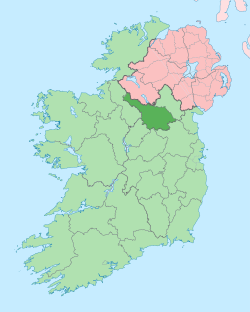
Owengallees (from Irish: Abhainn gallaois meaning 'Rocky River') is a townland in the civil parish of Templeport, County Cavan, Ireland. It lies in the Roman Catholic parish of Templeport and barony of Tullyhaw.

Geography
Owengallees is bounded on the north by Gortnacargy in Corlough parish and Newtown, Templeport townlands, on the west by Drumlougher and Stranadarragh townlands, on the south by Boley townland and on the east by Gowlagh South, Mullaghmore, Templeport and Lakefield townlands. Its chief geographical features are Bunerky Lough (Irish = Loch Bun Adhairc = The Lake of the Butt of the Horn),[1][2] Lakefield Lough, the River Blackwater, County Cavan, a forestry plantation, a spring well, some dug wells and some stone quarries. Owengallees is traversed by the L1037 road, minor roads and rural lanes. The townland covers 470 statute acres.[3] A sub-division of the townland is called Owendoon (Abhain a Dúin = The Rivers of the Fort).
History
Up until the 19th century Owengallees also included the modern townland of Drumlougher as a subdivision. Another name for Owengallees was Cunnoocenanare and Cossaunnanare (Irish Cnuas-na-ngadhar meaning 'the gathering of the hounds' and Casan na ngadhar meaning "the path of the hounds")[4]
The 1609 Baronial Map depicts the townland as Owngalles.[5] The 1652 Commonwealth Survey lists the townland as Owen Gallice. The 1665 Down Survey map depicts it as Owneganlis.[6] William Petty's 1685 map depicts it as Owenganlis.[7]
On 12 November 1590 Queen Elizabeth I of England granted a pardon (No. 5489) to James O Doylan, of Ownygalleise, horsekeeper for fighting against the Queen's forces.[8]
In the Plantation of Ulster by grant dated 4 June 1611, King James VI and I granted, inter alia, two polls of Owingallis to Breene Og Magauran, gentleman.[9] He was the son of Brian Óg Mág Samhradháin who was chief of the McGovern clan until his death in 1584 (On 30 April 1605 King James VI and I had granted a pardon to him as Brian McGaran of Tolaghagh, for fighting against the King's forces.[10]). An Inquisition held in Cavan Town on 24 October 1631 found that the said Brian Óg McGovern by deed of trust dated 20 November 1614 granted the lands of Lissconnaught (Irish= 'Lios Connachta', meaning The Fort of the Descendants of Conn) comprising 2 polls in Owengallees, 2 polls in Teeboy townland in Corlough parish and a half poll in Bartonny, to the use of himself and his wife Mary O'Birn and after their death for their son Edmond McGovern, born in 1616.[11] The said Brian Óg McGovern died on 1 October 1631.
The McGovern lands in Owengallees were confiscated in the Cromwellian Act for the Settlement of Ireland 1652 and were distributed as follows:
The 1652 Commonwealth Survey lists the proprietor as Lieutenant-Colonel Tristram Beresford, who also appears as proprietor for several other Templeport townlands in the same survey.
In the Hearth Money Rolls compiled on 29 September 1663[12] there were three Hearth Tax payers in Owengallis- Cormucke McEdegany, Daniell Magawran and Donell McEdagany.
A further confirming grant dated 3 November 1666 was made by King Charles II of England to the aforementioned Sir Tristram Beresford, 1st Baronet included, inter alia, 217 acres of profitable land plus 15 acres & 2 roods of unprofitable land in Owen-Gally or Owengallis.[13] By grant dated 11 September 1670 from King Charles II of England to said Sir Tristram Beresford, the lands of Owengally were included in the creation of a new Manor of Beresford.[14]
A synod of the Roman Catholic Provincial Council of Armagh was held in Owengallees on 25 May 1669 where the Bishop of Kilmore, Eugene Sweeney tried to depose Thomas Fitzsimons, the vicar general of the diocese.[15] Fitzsimons wrote- I was excommunicated once by virtue of a censure unjustly opposed by the late bishop of Kilmore in that farce of a council in Owengalles.[16] [17]
In the Templeport Poll Book of 1761 there was only one person registered to vote in Owengallees in the 1761 Irish general election[18] - Louther Kirkwood, who lived in the townland and owned a freehold there. He was entitled to cast two votes. The four election candidates were Charles Coote, 1st Earl of Bellomont and Lord Newtownbutler (later Brinsley Butler, 2nd Earl of Lanesborough), both of whom were then elected Member of Parliament for Cavan County. The losing candidates were George Montgomery (MP) of Ballyconnell and Barry Maxwell, 1st Earl of Farnham. Kirkwood voted for Newtownbutler and Coote. Absence from the poll book either meant a resident did not vote or more likely was not a freeholder entitled to vote, which would mean most of the inhabitants of Owengallees.
The 1790 Cavan Carvaghs list spells the name as Uwengallish.[19]
In 1804 the aforesaid Lowther Kirkwood of Mullinagrave, parish of Templeport, Co. Cavan, gentleman made the following will[20]-
2 July 1804. To his grandnephew Lowther Brien, city of Dublin, attorney, and his heirs his lands of Awengallis, Ballylenan, Ballymagirill, Stranadarragh, Carnagimlie, Cullagh, Drumleden, Leitry [Leitra], Corlagh, Lananleragh [Lannanerriagh], Gowlanlea and Drumlogher, Co. Cavan, held under lease from the Beresford family. He had begun a suit in Chancery, Ireland, against John Brien, late of Salvon, Co. Fermanagh, deceased, for setting aside a fradulent deed obtained by said John Brien, which suit against the representatives is to be continued by said Lowther Brien, his sole exor. Witnesses: John Johnston and Andrew Rutledge, both of Ballymagiril, and Thos. Stephenson, Drumleaden, Co. Cavan, gent. Memorial witnessed by: said Andrew Rutledge, and John Balfour, city of Dublin, attorney.
The Tithe Applotment Books for 1827 list thirty three tithepayers in the townland.[21]
The Owengallees Valuation Office Field books are available for 1839-1840.[22][23][24][25]
Griffith's Valuation of 1857 lists twenty nine landholders in the townland.[26]
On 6 July 1857 the Incumbered Estates Commission published the following notice[27]-
In the Matter of the Estate of James Brien, Geo. Brien, Edward Brien and Francis Brien, Owners. Exparte by Isabella Crummer, Petitioner. The commissioners having ordered a Sale of the Lands of Shanadaragh and Curnagunlogh, Cullegh, Drumlohgher, Drumledin, Sananaragh, and Drumledin, and Corlough, situate in the Barony of Tullyhaw, and County of Cavan, held under lease dated the 10th April, 1718, from the Bishop Raphoe, for lives renewable for ever, and which Lands are included in the denominations of Ballymagord, Owngally, Gortneglough, Drumedin or Ballylennin, in said lease mentioned:
A deed dated 10 June 1875 now in the Cavan Archives Service (ref P017/0096) is described as-
Notice issued by the Landed Estates Court, Ireland, to tenants and adjoining owners and occupiers, informing them of the sale of part of the lands of Owengallees (Owen Gallows otherwise Owen Galles otherwise Owen Gallils), barony of Tullyhaw, County Cavan, containing 397 acres, 2 roods and 16 perches, the property of Henry George l'Estrange. Document incorporates rental and map of the lands to be sold.[28]
In the 1860s George L'Estrange published monthly weather reports from Owendoon House in Owengallees in Symons's monthly meteorological magazine.Symons's monthly meteorological magazine In April 1859 a Report was prepared for Archbishop Beresford- relative to a piece of land called Doonbeg in the Parish of Templeport, Barony of Tullyhaw and County of Cavan claimed by Mr L'Estrange as part of Owengallis".[29]
The author Mrs Augusta Wardell, née Hunt, was a native of the townland. She published a book in 1912 entitled "Folk Tales of Breffny" under the pen name 'Bunda Hunt'.[30] A deed dated 28 May 1920 describes the family members.[31]
Census
| Year | Population | Males | Females | Total Houses | Uninhabited |
|---|---|---|---|---|---|
| 1841 | 174 | 82 | 92 | 30 | 1 |
| 1851 | 123 | 58 | 65 | 20 | 0 |
| 1861 | 95 | 48 | 47 | 16 | 1 |
| 1871 | 54 | 33 | 31 | 13 | 1 |
| 1881 | 76 | 40 | 36 | 14 | 0 |
| 1891 | 82 | 42 | 40 | 15 | 0 |
In the 1901 census of Ireland, there are twenty families listed in the townland,[32] and in the 1911 census of Ireland, there are only eighteen families listed in the townland.[33]
Antiquities
- An earthen ringfort.[34]
- A crannóg 100 metres from the shore in Lakefield Lough.[35]
- A Bronze Age bronze axe in the National Museum of Ireland was found in Owengallees in 1927.Templeport Development Association - History - Bronze Axe heads
- A bridge on the River Blackwater
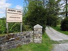
- Owendoon House built c.1850, now known as Jampa Ling Buddhist Retreat.[36] Bawnboy and Templeport History Heritage and Folklore - Past and Present
- A boathouse
See also
References
- "Coarse Fishing, Lake Bunerky (Arderry Lake), Cavan, Ireland. Coarse Angling, Lake Bunerky (Arderry Lake), Cavan, Ireland". www.prebait.com.
- "Bunerky Lough, Ireland - 0.730sq km - Facts, Map". www.lakepedia.com.
- "IreAtlas". Retrieved 29 February 2012.
- "Bawnboy and Templeport History Heritage and Folklore - Cunnoocenanare". www.bawnboy.com.
- "National Archives Dublin" (PDF).
- Trinity College Dublin: The Down Survey of Ireland.
- "Down Survey Maps | The Down Survey Project". downsurvey.tcd.ie.
- "Enhanced British Parliamentary Papers On Ireland". www.dippam.ac.uk.
- Chancery, Ireland (11 April 1800). "Calendar of the Patent Rolls of the Chancery of Ireland". A. Thom – via Google Books.
- Calendar of the Patent Rolls of the Chancery of Ireland. - (Dublin 1800.) (angl.) 372 S. 1800. p. 43. Retrieved 8 January 2017.
- "Inquisitionum in Officio Rotulorum Cancellariae Hiberniae Asservatarum Repertorium". command of his majesty King George IV. In pursuance of an address of the house of Commons of Great Britain (an Ireland). 11 April 1829 – via Google Books.
- The Hearth Money Rolls for the Baronies of Tullyhunco and Tullyhaw, County Cavan, edited by Rev. Francis J. McKiernan, in Breifne Journal. Vol. I, No. 3 (1960), pp. 247-263
- "Commissioners of Public Records in Ireland : fourteenth and fifteenth reports with appendix, 1824-25". HMSO. 11 April 1825 – via Internet Archive.
- "Calendar of the state papers relating to Ireland preserved in the Public Record Office. 1625-[1670]". London, Printed for H. M. Stationery Off., by Eyre and Spottiswoode. 11 April 1900 – via Internet Archive.
- Lynch, De Praesulibus Hiberniae, Vol. I, p. 256.
- Francis J. MacKiernan, Thomas Fitzsimons (1614-80), in Breifne Journal, Vol. IX, no. 37 (2001), pp. 313-336.
- pp.348-349
- "Bawnboy and Templeport - Poll Book 1761". www.bawnboy.com.
- Deeds (Ireland), Registry of (11 April 1984). "Abstracts of Wills: 1785-1832". Stationery Office – via Google Books.
- and and , in the Tithe Applotment Books 1827
- "Valuation Office Books". census.nationalarchives.ie.
- "Griffith's Valuation". www.askaboutireland.ie.
- "Co. Cavan; Ireland Newspaper Abstracts".
- Hunt, Bampton (11 April 1912). "Folk tales of Breffny". London : Macmillan – via Internet Archive.
- "Memorial extract — Registry of Deeds Index Project". irishdeedsindex.net.
- "National Archives: Census of Ireland 1911". www.census.nationalarchives.ie.
- "National Archives: Census of Ireland 1911". www.census.nationalarchives.ie.
- Site number 1037 in "Archaeological Inventory of County Cavan", Patrick O’Donovan, 1995, where it is described as- Raised circular area (int. diam. 27.5m) enclosed by a substantial earthen bank, which has been removed from SSE-S-SW, and a wide, deep fosse. Break in bank with accompanying causeway at SE represents original entrance.
- Site number 1586 in "Archaeological Inventory of County Cavan", Patrick O’Donovan, 1995, where it is described as- Small, circular, tree-covered island (diam. c. 12m) situated in Larkfield Lough, c.100m from the shoreline.
- "Jampa Ling Buddhist Centre, County Cavan".
