Orsay, Inner Hebrides
Orsay (Scottish Gaelic: Orasaigh) is a small island in the Inner Hebrides of Scotland. It lies a short distance off the west coast of the island of Islay and shelters the harbour of the village of Portnahaven.
| Gaelic name | Orasaigh |
|---|---|
| Location | |
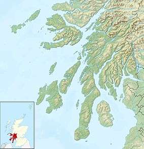 Orsay Orsay shown within Argyll and Bute | |
| OS grid reference | NR165515 |
| Coordinates | 55.674°N 6.511°W |
| Physical geography | |
| Island group | Islay |
| Area | 24 hectares (0.1 sq mi)[1] |
| Highest elevation | 24 metres (79 ft)[2] |
| Administration | |
| Sovereign state | United Kingdom |
| Country | Scotland |
| Council area | Argyll and Bute |
| Demographics | |
| Population | 0 |
| References | [3] |
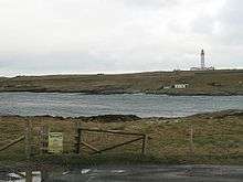
Orsay seen from Port Wemyss, south-east of Portnahaven
The Rinns of Islay lighthouse was built on Orsay in 1825 by Robert Stevenson.[4]
Footnotes
- Rick Livingstone’s Tables of the Islands of Scotland (pdf) Argyll Yacht Charters. Retrieved 12 Dec 2011.
- Ordnance Survey. OS Maps Online (Map). 1:25,000. Leisure.
- Haswell-Smith, Hamish (2004). The Scottish Islands. Edinburgh: Canongate. ISBN 978-1-84195-454-7.
- "Rinns of Islay lighthouse". Northern Lighthouse Board. Retrieved 6 February 2020.
gollark: I see.
gollark: Well, basically, hexagons good.
gollark: We have a 30 days satisfaction or your belief back guarantee.
gollark: Have you tried Hexicantilism? You can keep your existing religion!
gollark: https://radio-ic.osmarks.net/x.ogg has now been UTTERLY deployed.
External links
| Wikimedia Commons has media related to Orsay, Inner Hebrides. |
This article is issued from Wikipedia. The text is licensed under Creative Commons - Attribution - Sharealike. Additional terms may apply for the media files.