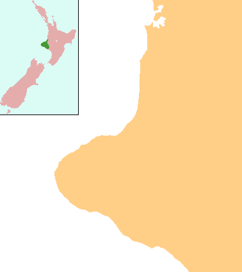
Omata
Omata is a locality in Taranaki, in the western North Island of New Zealand.[1] It is located on State Highway 45 just southwest of New Plymouth.[2][3]
Omata | |
|---|---|
 Omata | |
| Coordinates: 39°5′38″S 174°1′13″E | |
| Country | New Zealand |
| Region | Taranaki |
| District | New Plymouth District |
| Population (2013) | |
| • Total | 540 |
According to the 2013 New Zealand census, Omata and its surrounds have a population of 540, an increase of 66 people since the 2006 census.[4]
The area was the site of the Omata Stockade, built to house soldiers during tensions at the time of the First Taranaki War in 1860–61, and is near the site of the Battle of Waireka on 28 March 1860.[5]
Education
Omata School is a coeducational full primary (years 1–8) school with a roll of 182 students as of March 2020.[6][7] In 2003, the school celebrated its 150th jubilee.[8]
Omata electorate
Omata was an electorate for the New Zealand House of Representatives from 1853 to 1870. Seven Members of Parliament represented the electorate in the 1st to 4th Parliament.
References
- "Place name detail: Omata". New Zealand Gazetteer. Land Information New Zealand. Retrieved 30 October 2007.
- Peter Dowling (editor) (2004). Reed New Zealand Atlas. Reed Books. pp. map 34. ISBN 0-7900-0952-8.CS1 maint: extra text: authors list (link)
- Roger Smith, GeographX (2005). The Geographic Atlas of New Zealand. Robbie Burton. pp. map 84. ISBN 1-877333-20-4.
- 2013 Census QuickStats about a place : Omata
- "The New Zealand Wars" by James Cowan, 1922, chapter 19.
- "New Zealand Schools Directory". New Zealand Ministry of Education. Retrieved 26 April 2020.
- Education Counts: Omata School
- "Jubilees & reunions: Omata-Hurford School 150th Jubilee". Education Gazette New Zealand. 81 (20). 4 November 2002.