Ohio State Route 257
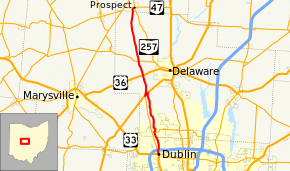
State Route 257 (SR 257, OH 257) is a 26.19-mile (42.15 km) north - south state highway in the central portion of the U.S. state of Ohio. The highway's southern terminus is in the northwestern Columbus suburb of Dublin at a roundabout intersection with U.S. Route 33 (US 33) and SR 161. This mainly two-lane highway follows the eastern side of the Scioto River from Dublin to its junction with US 42. After crossing over the river with the U.S. highway, SR 257 parallels the river's western bank. SR 257 has its northern terminus at a T-intersection with SR 47 on the western village limits of Prospect. SR 257 was created in 1926, and extended in 1935 and 1937.
| ||||
|---|---|---|---|---|
| General Thaddeus Kosciusko Memorial Highway | ||||
 | ||||
| Route information | ||||
| Maintained by ODOT | ||||
| Length | 26.19 mi[1][2][3] (42.15 km) | |||
| Existed | 1926[4][5]–present | |||
| Major junctions | ||||
| South end | ||||
| North end | ||||
| Location | ||||
| Counties | Franklin, Delaware, Marion | |||
| Highway system | ||||
| ||||
Route description
| County Log Point | Volume | ||||
|---|---|---|---|---|---|
| 0.06 | 17,100 | ||||
| 0.842 | 24,450 | ||||
| 0.112 | 18,470 | ||||
| 1.25 | 15,870 | ||||
| 3.194 | 6,970 | ||||
| 7.75 | 2,530 | ||||
| 8.478 | 8,110 | ||||
| 12.728 | 6,180 | ||||
| 14.35 | 1,560 | ||||
| 22.618 | 720 | ||||
| 0.486 | 720 | ||||
Along its way, SR 257 travels primarily north through northwestern Franklin County, western Delaware County and the extreme southern part of Marion County, following the Scioto River for most of the way.[7] There are no segments of SR 257 that are included within the National Highway System (NHS). The NHS is a network of highways identified as being most important for the economy, mobility and defense of the nation.[8]
SR 257 starts at the intersection of US 33 / SR 161. The route moves north intersecting with Emerald Parkway. SR 257 continues north to Hard Road, and past Thaddeus Kosciuszko Park. After crossing the Franklin–Delaware county line, the next major junction is with SR 750 at the Columbus Zoo and Aquarium and the O'Shaughnessy Dam. From here to US 42 the route follows the eastern bank of O'Shaughnessy Reservoir. The next intersection is Seldom Seen Road. Two miles later, SR 257 meets Home Road at a traffic circle. Home Road provides access to SR 745 heading west and to Sawmill Parkway and Liberty Rd heading east.[7]
SR 257 continues north to signaled intersection with US 42 and runs concurrently with US 42 for about 1 mile within Concord Township. The route travels southwest with US 42 across the Scioto River. At the signalized northern terminus of SR 745 the concurrency ends, as SR 257 turns north. SR 257 passes through the former communities of Bellpoint (Concord Township) and White Sulfur Springs Station (Scioto Township)[9] on the way to intersecting with US 36 about 3.5 miles (5.6 km) north of US 42. Continuing north, SR 257 crosses SR 37 at a flashing red light. After nine miles, the route crosses into Marion County prior to ending at OH 47 in Prospect, crossing minor roads within Thompson Township in between.[7]
History

The SR 257 designation was applied in 1926. Originally, the highway was routed along its present southernmost alignment along the eastern banks of the Scioto River between Dublin and its northeastern junction with US 42.[4][5]
In 1935, SR 257 was extended via a short concurrency with US 42 across the Scioto River, then north along its present alignment along the western side of the river to a new northern terminus at SR 37 west of Delaware.[10][11] Then, two years after its first northward extension, SR 257 was extended to the north again, this time to its present northern terminus at SR 47 in Prospect.[12][13]
SR 257 was designated the General Thaddeus Kosciusko Memorial Highway in December 1975.[14]
Major intersections
| County | Location | mi[1][2][3] | km | Destinations | Notes |
|---|---|---|---|---|---|
| Franklin | Dublin | 0.00 | 0.00 | Southern terminus at signalized intersection | |
| Delaware | Liberty Township | 3.94 | 6.34 | Signalized intersection marking western terminus of SR 750 | |
| Concord Township | 10.72 | 17.25 | Signalized intersection marking northeastern end of the US 42 concurrency | ||
| 11.29 | 18.17 | Signalized intersection marking southwestern end of the US 42 concurrency; northern terminus of SR 745 | |||
| Scioto Township | 14.75 | 23.74 | |||
| 17.18 | 27.65 | ||||
| Marion | Prospect | 26.19 | 42.15 | Northern terminus at T-intersection | |
1.000 mi = 1.609 km; 1.000 km = 0.621 mi
| |||||
References
- Ohio Department of Transportation. "Technical Services Straight Line Diagrams: SR 257, Franklin County" (PDF). Archived from the original (PDF) on 2011-10-08. Retrieved 2006-12-06.
- Ohio Department of Transportation. "Technical Services Straight Line Diagrams: SR 257, Delaware County" (PDF). Archived from the original (PDF) on 2011-10-08. Retrieved 2006-12-06.
- Ohio Department of Transportation. "Technical Services Straight Line Diagrams: SR 257, Marion County" (PDF). Archived from the original (PDF) on 2011-10-08. Retrieved 2006-12-06.
- Map of Ohio Showing State Routes (MrSID) (Map). Cartography by ODHPW. Ohio Department of Highways and Public Works. August 1925. Retrieved 2011-04-28.
- Map of Ohio Showing State Routes (MrSID) (Map). Cartography by ODHPW. Ohio Department of Highways and Public Works. August 1926. Retrieved 2011-04-28.
- Staff. "Transportation Information Mapping System". Ohio Department of Transportation. Archived from the original on 2013-09-16. Retrieved 2013-08-17.
- Google (2013-08-18). "Ohio State Route 257" (Map). Google Maps. Google. Retrieved 2013-08-18.
- National Highway System: Ohio (PDF) (Map). Federal Highway Administration. December 2003. Retrieved 2011-04-28.
- http://www.forgottenoh.com/GhostTowns/delawareco.html |Ghost Towns of Delaware County| Accessed on 23 Apr 2014
- Map of Ohio Showing State Highway System (MrSID) (Map). Cartography by ODOH. Ohio Department of Highways. 1934. Retrieved 2011-04-28.
- Official Ohio Highway Map (MrSID) (Map). Cartography by ODOH. Ohio Department of Highways. 1935. Retrieved 2011-04-28.
- Official Ohio Highway Map (MrSID) (Map). Cartography by ODOH. Ohio Department of Highways. 1936. Retrieved 2011-04-28.
- Official Ohio Highway Map (MrSID) (Map). Cartography by ODOH. Ohio Department of Highways. 1937. Retrieved 2011-04-28.
- "Ohio Administrative Code: ORC 5533.29 General Thaddeus Kosciusko memorial highway". Retrieved 2011-09-19.
