Ohio State Route 256
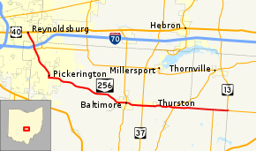
State Route 256 (SR 256) is a 25.99-mile (41.83 km) east–west state highway in the central portion of the U.S. state of Ohio. The western terminus of SR 256 is at a T-intersection with U.S. Route 40 (US 40) in Reynoldsburg. Its eastern terminus is at a T-intersection with SR 13 approximately 5.50 miles (8.85 km) west-northwest of Somerset.
| ||||
|---|---|---|---|---|
 | ||||
| Route information | ||||
| Maintained by ODOT | ||||
| Length | 25.99 mi[1] (41.83 km) | |||
| Major junctions | ||||
| West end | ||||
| East end | ||||
| Location | ||||
| Counties | Franklin, Fairfield, Perry | |||
| Highway system | ||||
| ||||

Route description
SR 256 runs through parts of Franklin, Fairfield and Perry Counties. No portion of SR 256 is included within the National Highway System (NHS). The NHS is a system of highways deemed most important for the nation's economy, mobility and defense.[2]
History
The current route of SR 256 between Reynoldsburg and Baltimore was commissioned as SR 204, in 1923.[3][4] In 1927, SR 256 was commissioned on that section of SR 204.[5][6] SR 256 was extended east to an intersection with SR 13, in 1937.[7][8]
Major intersections
| County | Location | mi[1] | km | Destinations | Notes |
|---|---|---|---|---|---|
| Franklin | Reynoldsburg | 0.00 | 0.00 | Eastbound US 40 to SR 256 / SR 256 to eastbound US 40 only | |
| Fairfield | Pickerington | 1.66 | 2.67 | Exit 112 (I-70) | |
| 1.97 | 3.17 | Western terminus of SR 204 | |||
| Baltimore | 14.74 | 23.72 | |||
| Walnut Township | 16.56 | 26.65 | |||
| 20.06 | 32.28 | ||||
| Fairfield–Perry county line | Richland–Thorn township line | 24.33 | 39.16 | Northern terminus of SR 664 | |
| Perry | Thorn Township | 25.99 | 41.83 | ||
| 1.000 mi = 1.609 km; 1.000 km = 0.621 mi | |||||
References
- Ohio Department of Transportation. "Technical Services Straight Line Diagrams". Retrieved 2010-11-01.
- National Highway System: Ohio (PDF) (Map). Federal Highway Administration. December 2003. Retrieved 2010-10-31.
- Ohio Department of Highways and Public Works (April 1922). Map of Ohio State Highways Showing All Improved Roadways and Indicating System Constructed Under Administration of Gov. Harry L. Davis (PDF) (Map). c. 1:563,200. Columbus: Ohio Department of Highways and Public Works. Retrieved October 30, 2013.
- Ohio Department of Highways and Public Works (July 1923). Map of Ohio Showing State Routes (PDF) (Map). 1:760,320. Columbus: Ohio Department of Highways and Public Works. Retrieved October 30, 2013.
- Ohio Department of Highways and Public Works (August 1, 1926). Map of Ohio Showing State Routes (PDF) (Map). 1:760,320. Columbus: Ohio Department of Highways and Public Works. OCLC 5673562. Retrieved October 30, 2013.
- Ohio Department of Highways and Public Works (June 1, 1927). Map of Ohio Showing State Routes (PDF) (Map). 1:760,320. Columbus: Ohio Department of Highways and Public Works. OCLC 5673562. Retrieved October 30, 2013.
- Ohio Department of Highways (1936). Official Highway Map of Ohio (PDF) (Map). 1:760,320. Columbus: Ohio Department of Highways. OCLC 5673562. Retrieved October 30, 2013.
- Ohio Department of Highways (1937). Official Highway Map of Ohio (PDF) (Map). 1:760,320. Columbus: Ohio Department of Highways. OCLC 5673562, 16960304. Retrieved October 30, 2013.
External links