Ohaupo
Ohaupo or Ōhaupō is a rural community in the Waipa District and Waikato region of New Zealand's North Island. It is located on State Highway 3, about halfway between Hamilton and Te Awamutu.
Ōhaupō | |
|---|---|
Rural locality | |
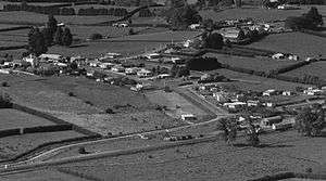
 Aerial photo of Ohaupo in April 1964 | |
 Ōhaupō Location of Ōhaupō | |
| Coordinates: 37.91989°S 175.307465°E | |
| Country | New Zealand |
| Region | Waikato |
| Territorial authority | Waipa District |
| Time zone | UTC+12 (NZST) |
| • Summer (DST) | UTC+13 (NZDT) |
| Postcode | 3803 |
| Area code(s) | 07 |
| Website | https://www.waipadc.govt.nz/ |
The Ōhaupō area and surrounding Ngāhinapōuri, Te Rore and Harapēpē area were military outposts during the Waikato War and a military fortification was built about one kilometre north of the township in April 1864.[1] Other military fortifications had been built at nearby Ngāhinapōuri, Tuhikaramea and Te Rore four months earlier, in December 1863.[2]
The earliest European settlers in Ōhaupō were Bohemian militiamen from the Pūhoi settlement north of Auckland. As of 2015, many descendants of these militiamen still lived in the area.[3]
The New Zealand Ministry for Culture and Heritage gives a translation of "place of a breeze at night" for Ōhaupō.[4]
The Ohaupo railway station was a train station on the North Island Main Trunk[5][6] It included a ladies' waiting room, public vestibule, ticket lobby, stationmaster's office, an asphalt platform, goods shed and a 7-room stationmaster's house.[7] In 1927 the station was handling almost 2,700 tons of fertiliser each year.[8]
The Mystery Creek Events Centre east of the township hosts the Southern Hemisphere's largest agricultural event, Fieldays.
Education
Ohaupo School is a co-educational state primary school,[9][10] with a roll of 208 as of March 2020.[11]
Kaipaki School is another co-educational state primary school located east of the township,[12][13] with a roll of 127.[14]
References
- "NZ History profile". nzhistory.govt.nz. New Zealand Ministry for Culture and Heritage.
- Ritchie, Neville. "The Waikato War of 1863-64" (PDF). doc.govt.nz. Department of Conservation.
- Swarbick, Nancy. "Waikato places - Te Awamutu". Te Ara - the Encyclopedia of New Zealand. New Zealand Ministry for Culture and Heritage.
- "1000 Māori place names". New Zealand Ministry for Culture and Heritage. 6 August 2019.
- New Zealand Railway and Tramway Atlas (First ed.). Quail Map Co. 1965. pp. 3 & 4.
- Pierre, Bill (1981). North Island Main Trunk. Wellington: A.H&A.W Reed. pp. 289–290. ISBN 0589013165.
- "Ohaupo". nzetc.victoria.ac.nz. 1902. Retrieved 9 April 2016.
- "Dairying Industry". The New Zealand Herald. 19 July 1927 – via National Library of New Zealand.
- "Ohaupo School Official School Website". ohaupo.school.nz.
- "Ohaupo School Ministry of Education School Profile". educationcounts.govt.nz. Ministry of Education.
- "Ohaupo School Education Review Office Report". ero.govt.nz. Education Review Office.
- "Kaipaki School Official School Website". kaipaki.schoolzone.net.nz. Archived from the original on 19 October 2007. Retrieved 23 April 2020.
- "Kaipaki School Ministry of Education School Profile". educationcounts.govt.nz. Ministry of Education.
- "Kaipaki School Education Review Office Report". ero.govt.nz. Education Review Office.