Nuthe-Urstromtal
Nuthe-Urstromtal is a municipality in the Teltow-Fläming district of Brandenburg, Germany. By area, it is the largest rural municipality ("Gemeinde") in Germany.
Nuthe-Urstromtal | |
|---|---|
 Coat of arms | |
Location of Nuthe-Urstromtal within Teltow-Fläming district 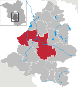 | |
 Nuthe-Urstromtal  Nuthe-Urstromtal | |
| Coordinates: 52°07′00″N 13°11′59″E | |
| Country | Germany |
| State | Brandenburg |
| District | Teltow-Fläming |
| Subdivisions | 23 Ortsteile |
| Government | |
| • Mayor | Stefan Scheddin |
| Area | |
| • Total | 337.84 km2 (130.44 sq mi) |
| Elevation | 42 m (138 ft) |
| Population (2018-12-31)[1] | |
| • Total | 6,603 |
| • Density | 20/km2 (51/sq mi) |
| Time zone | CET/CEST (UTC+1/+2) |
| Postal codes | 14947 |
| Dialling codes | 03371 |
| Vehicle registration | TF |
| Website | www.nuthe-urstromtal.de |
Demography
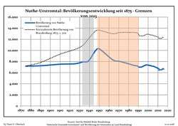 Development of Population since 1875 within the Current Boundaries (Blue Line: Population; Dotted Line: Comparison to Population Development of Brandenburg state; Grey Background: Time of Nazi rule; Red Background: Time of Communist rule)
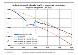 Recent Population Development and Projections (Population Development before Census 2011 (blue line); Recent Population Development according to the Census in Germany in 2011 (blue bordered line); Projection by the Brandenburg state for 2005-2030 (yellow line); Projection by the Brandenburg state for 2014-2030 (red line); Projection by the Bertelsmann Foundation for 2012-2030 (green line)
|
|
|
gollark: As I said, according to that Wikipedia article, even just relatively small-scale surveillance has *already been abused* to harm activists.
gollark: And besides, I don't care if it's constitutional, I care if it's actually ethical.
gollark: Er, how lack of privacy could be used against you, that is.
gollark: I mean, it is, given that privacy is just kind of important *anyway* regardless of how it could be used against you.
gollark: And "If you have nothing to hide you have nothing to fear" is, well, a complete and total lie.
References
- "Bevölkerung im Land Brandenburg nach amtsfreien Gemeinden, Ämtern und Gemeinden 31. Dezember 2018". Amt für Statistik Berlin-Brandenburg (in German). July 2019.
- Detailed data sources are to be found in the Wikimedia Commons.Population Projection Brandenburg at Wikimedia Commons
Towns and municipalities in Teltow-Fläming | ||
|---|---|---|
Coat of arms of Teltow-Fläming district | ||
| Authority control |
|
|---|
This article is issued from Wikipedia. The text is licensed under Creative Commons - Attribution - Sharealike. Additional terms may apply for the media files.