Ntoroko District
Ntoroko District is a district in the Western Region of Uganda. The district headquarters are in the Kibuuku town council.
Ntoroko District | |
|---|---|
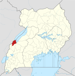
 District location in Uganda | |
| Coordinates: 01°06′N 30°24′E | |
| Country | |
| Region | Western Region |
| Sub-region | Rwenzori sub-region |
| Capital | Ntoroko |
| Area | |
| • Total | 1,236 km2 (477 sq mi) |
| Elevation | 640 m (2,100 ft) |
| Population (2014 Census) | |
| • Total | 67,005 |
| • Density | 57.35/km2 (148.5/sq mi) |
| Time zone | UTC+3 (EAT) |
| Website | www |
Location

Ntoroko District is one of the two Ugandan districts west of the Rwenzori Mountains, the other being Bundibugyo District. The Ntoroko District is bordered by the Democratic Republic of the Congo to the west and north, Hoima District to the north-east, Kibaale District to the east, Kabarole District to the south, and Bundibugyo District to the south-west. The town of Ntoroko is approximately 144 kilometres (89 mi), by road, north-east of Kasese, the largest town in the Rwenzururu sub-region[1] This location is approximately 376 kilometres (234 mi), by road, west of Kampala, the capital and largest city of Uganda.[2]
Overview
The Ntoroko District was created by the Ugandan Parliament and became operational on 1 July 2010. Before that, the district was part of the Bundibugyo District.[3]
Population
In 1991, the national population census estimated the district population at 24,300. The national census in 2002 estimated the population at 51,100. In 2014, the national census and household survey enumerated the district population at 67,005.[4]
See also
References
- Globefeed.com (19 January 2018). "Distance between Kasese Post Office, Rwenzori Road, Kasese, Uganda and Ntoroko, Western Region, Uganda". Globefeed.com. Retrieved 19 January 2018.
- Globefeed.com (19 January 2018). "Distance between Post Office Building, Kampala Road, Kampala, Uganda and Ntoroko, Western Region, Uganda". Globefeed.com. Retrieved 19 January 2018.
- Cyprian Musoke, Milton Olupot and Mary Karugaba (22 April 2010). "Government Names 14 New Districts". New Vision. Archived from the original on 29 October 2013. Retrieved 20 May 2014.
- Uganda Bureau of Statistics (27 August 2014). "The population development of Ntoroko District as well as related information and services (1991 to 2014)". Citypopulation.de Quoting Uganda Bureau of Statistics (UBOS). Retrieved 19 January 2018.