Norton Parish, New Brunswick
Norton is a civil parish[lower-alpha 1] in Kings County, New Brunswick, Canada.[2] For governance purposes it is divided between the town of Hampton,[3] the village of Norton,[3] and the local service district of the parish of Norton.[4]
Norton Parish | |
|---|---|
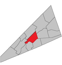 Location within Kings County, New Brunswick. | |
| Coordinates: 45.84°N 64.59°W | |
| Country | |
| Province | |
| County | Queens County |
| Established | 1795 |
| Area | |
| • Land | 144.76 km2 (55.89 sq mi) |
| Population (2016)[1] | |
| • Total | 1,301 |
| • Density | 9.0/km2 (23/sq mi) |
| • Pop 2011-2016 | |
| • Dwellings | 536 |
| Time zone | UTC-4 (AST) |
| • Summer (DST) | UTC-3 (ADT) |
History
Norton Parish was created in 1795 from Sussex Parish and Kingston Parish: possibly named for Norton, near Taunton, in southern Massachusetts, which was the original home of many of the first settlers to this area. Writer Emily Elizabeth Shaw Beavan worked in the parish as a young teacher.[5]
Delineation
Norton Parish is defined in the Territorial Division Act[6] as being bounded:
- East by Sussex and Studholm Parishes; north by Kingston and Springfield Parishes; south by the Kennebecasis River and the centre of the old Westmorland Road,[lower-alpha 2] and west by Kingston Parish and the lower line of lot number fourteen, granted to John Fritch, prolonged southeasterly.
Communities
Parish population total does not include incorporated municipalities (in bold):
|
|
Demographics
Access Routes
Highways and numbered routes that run through the parish, including external routes that start or finish at the parish limits:[10]
|
|
|
|
See also
Notes
- Civil parishes served a variety of government functions until 1966, when the new Municipalities Act stripped them of their responsibilities; they continue to provide convenient boundaries for government uses, especially electoral districts and local service districts. Statistics Canada uses civil parishes as census subdivisions for all parts of the province that are not within municipalities and similar entities.
- The old Westmorland Road no longer appears on provincial highway maps.[7]
References
- "Census Profile, 2016 Census: Norton, Parish [Census subdivision], New Brunswick". Statistics Canada. Retrieved August 30, 2019.
- "Chapter T-3 Territorial Division Act". Government of New Brunswick. Retrieved 19 July 2020.
- "New Brunswick Regulation 85-6 under the Municipalities Act (O.C. 85-45)". Government of New Brunswick. Retrieved 19 July 2020.
- "New Brunswick Regulation 84-168 under the Municipalities Act (O.C. 84-582)". Government of New Brunswick. Retrieved 19 July 2020.
- "SHAW, EMILY ELIZABETH". Home – Dictionary of Canadian Biography. 2019-09-25. Retrieved 2019-09-25.
- "Territorial Division Act (R.S.N.B. 1973, c. T-3)". Government of New Brunswick website. Retrieved 24 August 2016.
- "No. 447" (PDF). 2015 Designated Highway Maps. Government of New Brunswick. Retrieved 24 August 2016.
- Statistics Canada: 2001, 2006 census
- 2011 Statistics Canada Census Profile: Norton Parish, New Brunswick
- Atlantic Canada Back Road Atlas ISBN 978-1-55368-618-7
Places adjacent to Norton Parish, New Brunswick | |
|---|---|
| Subdivisions |
|
|---|---|
| Cities | |
| Counties | |
| |