Northern Indochina subtropical moist forests
The Northern Indochina subtropical moist forests are a subtropical moist broadleaf forest ecoregion of northern Indochina, covering portions of Vietnam, Laos, Thailand, Myanmar, and China's Yunnan Province.[4][5]
| Northern Indochina subtropical moist forests | |
|---|---|
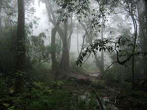 Forest on Fan Si Pan, Vietnam | |
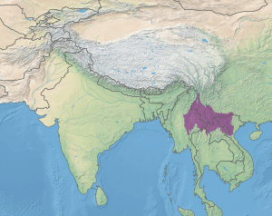 Map of the Northern Indochina subtropical moist forests ecoregion | |
| Ecology | |
| Realm | Indomalayan |
| Biome | tropical and subtropical moist broadleaf forests |
| Borders | List
|
| Bird species | 707[1] |
| Mammal species | 183[2] |
| Geography | |
| Area | 677,350 km2 (261,530 sq mi) |
| Countries | |
| Conservation | |
| Conservation status | vulnerable |
| Protected | 30,724 km² (7%)[3] |
Setting
The Northern Indochina subtropical forests occupy the highlands of northern Indochina, extending from northeastern Vietnam, where they cover the upper portion of the Red River watershed and the northern Annamite Range, across northern Laos, northernmost Thailand, and southeastern Yunnan to Shan State in eastern Myanmar. The ecoregion includes Fan Si Pan (3,147 meters), Vietnam's highest mountain.
The Northern Indochina subtropical forests are a transition between the tropical forests of Indochina and the subtropical and temperate forests of China and the Tibetan Plateau.[6]
Fauna
The ecoregion is home to over 183 species of mammals, and 707 species of birds.
Several mammals are endemic to the ecoregion – the Tonkin snub-nosed monkey (Rhinopithecus avunculus), northern white-cheeked gibbon (Hylobates leucogenys), Owston's palm civet (Chrotogale owstoni), Roosevelt's muntjac (Muntiacus rooseveltorum), and the Chaotung vole (Eothenomys olitor). Fea's muntjac (Muntiacus feae), Anderson's squirrel (Callosciurus quinquestriatus), and red-throated squirrel (Dremomys gularis) are near-endemic species, native to the ecoregion and one or more adjacent ecoregions.[7]
Protected areas
A 2017 assessment estimated that 30,724 km², or 7%, of the ecoregion is in protected areas. Another 34% of ecoregion's area is forested but outside of protected areas.[8] A 1997 assessment found a total of 15,948 km² protected in 19 protected areas.[9]
References
- "Northern Indochina subtropical forests". Terrestrial Ecoregions. World Wildlife Fund.
- "Northern Indochina subtropical forests". Terrestrial Ecoregions. World Wildlife Fund.
- Eric Dinerstein, David Olson, et al. (2017). An Ecoregion-Based Approach to Protecting Half the Terrestrial Realm, BioScience, Volume 67, Issue 6, June 2017, Pages 534–545; Supplemental material 2 table S1b.
- Encyclopedia of earth - Ecoregions
- "Northern Indochina subtropical forests". Terrestrial Ecoregions. World Wildlife Fund.
- Wikramanayake, Eric; Eric Dinerstein; Colby J. Loucks; et al. (2002). Terrestrial Ecoregions of the Indo-Pacific: a Conservation Assessment. Washington, DC: Island Press.
- "Northern Indochina subtropical forests". Terrestrial Ecoregions. World Wildlife Fund.
- Eric Dinerstein, David Olson, et al. (2017). An Ecoregion-Based Approach to Protecting Half the Terrestrial Realm, BioScience, Volume 67, Issue 6, June 2017, Pages 534–545; Supplemental material 2 table S1b.
- Wikramanayake, Eric; Eric Dinerstein; Colby J. Loucks; et al. (2002). Terrestrial Ecoregions of the Indo-Pacific: a Conservation Assessment. Washington, DC: Island Press.
External links
- "Northern Indochina subtropical forests". Terrestrial Ecoregions. World Wildlife Fund.
- World Wildlife Fund, ed. (2001). "Northern Indochina subtropical forests". WildWorld Ecoregion Profile. National Geographic Society. Archived from the original on 2010-03-08.