North Tibetan Plateau-Kunlun Mountains alpine desert
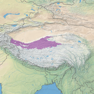
The North Tibetan Plateau-Kunlun Mountains alpine desert ecoregion (WWF ID:PA1011) covers a long stretch of mostly treeless alpine terrain across the northern edge of the Tibet Plateau. A variety of cold, dry habitats are found, including alpine meadows, steppe, desert, and cushion plant floral areas.[1][2]
| Ecoregion: North Tibetan Plateau-Kunlun Mountains alpine desert | |
|---|---|
 View of Western Kunlun Shan from the Tibet-Xinjiang highway | |
 Ecoregion territory (in purple) | |
| Ecology | |
| Realm | Palearctic |
| Biome | Montane grasslands and shrublands |
| Geography | |
| Countries | China |
| Coordinates | 35°45′N 85°45′E |
Location
In the northwest, the egoregion begins at the east edge of the Pamir Mountains, then covers the Kunlun Mountains in the north and the high plateau south to the Karakoram Mountains. From there it follows the Kunlun from west to east across the northern edge of the Tibet Plateau, on the south rim of the arid Tarim Basin. Elevations, higher in the northwest, are mostly above 5,000 meters, and the soils are often salty and barren. The region is dry, cold, and very remote. Permafrost lies under much of the territory.[1] Much of the eastern extension is within the Altun Shan National Nature Reserve.
Climate
The climate of the ecoregion is Tundra climate (Köppen climate classification ET), a local climate in which at least one month has an average temperature high enough to melt snow (0 °C (32 °F)), but no month with an average temperature in excess of 10 °C (50 °F).[3][4] Precipitation in much of the region is under 50 mm/year. Winds are strong and persistent.
Flora and fauna
The harsh environment supports only specialized plants and animals capable of managing the cold, dry climate. There are very limited stands of Asian spruce (Picea schrenkiana) and juniper shrubs on low, north-facing slopes where they can capture moisture or snow melt. Along riverbeds there are a few plants such as a salt-tolerant form of tamarisk (Myricaria), a woody plant the exists mostly underground. Some slopes below 5,300 meters support a high cold steppe community that features sedges (Carex), purple feathergrass (Stipa purpurea), falcate crazyweed (locoweed) (Oxytropis falcata).[5]
One mammal endemic to the region is the endangered Koslov's pika (Ochotona koslowi). The Koslov's pika ia a burrowing lagomorph that lives in dense family communities. The species had been identified in 1884 on the basis of two specimens, then 'lost' for over 100 years until scientists discovered some isolated communities in the Kunlun Mountains.[5]
See also
References
- "North Tibetan Plateau-Kunlun Mountains alpine desert". Encyclopedia of the Earth. Retrieved March 9, 2020.
- "Map of Ecoregions 2017". Resolve, using WWF data. Retrieved September 14, 2019.
- Kottek, M., J. Grieser, C. Beck, B. Rudolf, and F. Rubel, 2006. "World Map of Koppen-Geiger Climate Classification Updated" (PDF). Gebrüder Borntraeger 2006. Retrieved September 14, 2019.CS1 maint: multiple names: authors list (link)
- "Dataset - Koppen climate classifications". World Bank. Retrieved September 14, 2019.
- Li, W.; Zhang, H.; Liu, Z. (2006). "Brief report on the status of Kozlov's pika, Ochotona koslowi (Büchner), in the east Kunlun mountains of China". Integrative Zoology. Integrative Zoology 2006; 1: 22-24. 1 (1): 22–4. doi:10.1111/j.1749-4877.2006.00008.x. PMID 21395987.