Nimbong
Nimbong (also referred to as Nimbong Khasmahal) is a village in the Kalimpong I CD block in the Kalimpong Sadar subdivision of the Kalimpong district in the state of West Bengal, India.
Nimbong Nimbong Khasmahal | |
|---|---|
Village | |
 Nimbong Location in West Bengal, India  Nimbong Nimbong (India) | |
| Coordinates: 26.974194°N 88.590694°E | |
| Country | |
| State | West Bengal |
| District | Kalimpong |
| Population (2011) | |
| • Total | 2,659 |
| Time zone | UTC+5:30 (IST) |
| PIN | 734314 |
| Vehicle registration | WB |
| Lok Sabha constituency | Darjeeling |
| Vidhan Sabha constituency | Kalimpong |
| Website | kalimpongdistrict |
Geography
 |
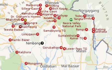
| Places in the Kalimpong Sadar subdivision in Kalimpong district CT: census town, R: rural/ urban centre, M: municipality, F: facility, NP: national park Abbreviations used in names – TG for Tea Garden (town/village) Owing to space constraints in the small map, the actual locations in a larger map may vary slightly |
Location
Nimbong is located at 26.974194°N 88.590694°E.
Nimbong is 78 km from Siliguri and 71 km from Kalimpong. It is at an altitude of 5,000 feet (1,500 m). Winters can be severely cold but there is normally no snowfall. During the monsoons, the roads get muddy and there are possibilities of landslides.[1][2][3]
Area overview
The map alongside shows the Kalimpong Sadar subdivision of Kalimpong district. Physiographically, this area forms the Kalimpong Range, with the average elevation varying from 300 to 3,000 metres (980 to 9,840 ft). This region is characterized by abruptly rising hills and numerous small streams.[4]It is a predominantly rural area with 77.67% of the population living in rural areas and only 22.23% living in the urban areas. While Kalimpong is the only municipality, Dungra is the sole census town in the entire area.[5] The economy is agro-based and there are 6 tea gardens in the Gorubathan CD block.[6]In 2011, Kalimpong subdivision had a literacy rate of 81.85%, comparable with the highest levels of literacy in the districts of the state.[7][8]While the first degree college in the subdivision was established at Kalimpong in 1962[9]the entire subdivision (and now the entire district), other than the head-quarters, had to wait till as late as 2015 (more than half a century) to have their first degree colleges at Pedong and Gorubathan.[10][11]
Note: The map alongside presents some of the notable locations in the subdivision. All places marked in the map are linked in the larger full screen map.
Demographics
According to the 2011 Census of India, Nimbong Khasmahal had a total population of 2,659 of which 1,368 (51%) were males and 1,291 (49%) were females. There were 311 persons in the age range of 0 to 6 years. The total number of literate people in Nimbong Khasmahal was 1,661 (70.74% of the population over 6 years).[12]
Tourism
It is a quiet and beautiful place in the lap of nature. “The charm of this place is its complete isolation from the madding crowd of metropolitan life” - it an ideal place for the adventure seeking tourist. There is a lot to see: from snow clad Himalayan ranges to untouched forests and hills all around. There are a variety of food and lodging amenities ranging from comfortable modern facilities to small places with home cooked food.[13]
References
- "Nimbong". North Bengal Tourism. Retrieved 5 April 2020.
- "Nimbong Village Resort". Nomadic Weekends. Retrieved 5 April 2020.
- "Zero – a fascinating place in Nimbong". North Bengal Tourism. Retrieved 8 March 2020.
- "District Census Handbook, Darjeeling, Series 20, Part XII A, 2011 Census of India" (PDF). Page 13: Physiography. Directorate of Census Operations, West Bengal. Retrieved 6 April 2020.
- "District Statistical Handbook 2013 Darjeeling". Table 2.4b. Department of Statistics and Programme Implementation, Government of West Bengal. Retrieved 6 April 2020.
- "About Kalimpong District". Tea Gardens. District administration. Retrieved 6 April 2020.
- "District Statistical Handbook 2013 Darjeeling". Table 4.5. Department of Statistics and Programme Implementation, Government of West Bengal. Retrieved 6 April 2020.
- "Provisional Population Totals Paper 1 of 2011 : West Bengal". Statement-4 Ranking of Districts by Literacy Rate in 2001 and 2011. Office of the Registrar General and & Census Commissioner, India, Ministry of Home Affairs, Government of India. Retrieved 2012-06-20.
- "Kalimpong College". College Admission. Retrieved 6 April 2020.
- "Government General Degree College at Pedong". GGDC. Retrieved 6 April 2020.
- "Government General Degree College, Gorubathan". GGDC. Retrieved 6 April 2020.
- "2011 Census – Primary Census Abstract Data Tables". West Bengal – District-wise. Registrar General and Census Commissioner, India. Retrieved 4 April 2020.
- "Kalimpong District - Tourism". Nimbong. District officials. Retrieved 8 March 2020.