Kolakham
Kolakham is a village in the Kalimpong II CD block in the Kalimpong Sadar subdivision of Kalimpong district in the state of West Bengal, India.
Kolakham | |
|---|---|
Village | |
 Kolakham Location in West Bengal, India  Kolakham Kolakham (India) | |
| Coordinates: 27°06′05″N 88°40′40″E | |
| Country | |
| State | West Bengal |
| District | Kalimpong |
| Time zone | UTC+5:30 (IST) |
| Vehicle registration | WB |
| Lok Sabha constituency | Darjeeling |
| Vidhan Sabha constituency | Kalimpong |
| Website | kalimpongdistrict |
Geography
 |
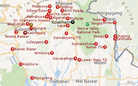
| Places in the Kalimpong Sadar subdivision in Kalimpong district CT: census town, R: rural/ urban centre, M: municipality, F: facility, NP: national park Abbreviations used in names – TG for Tea Garden (town/village) Owing to space constraints in the small map, the actual locations in a larger map may vary slightly |
Location
Kolakham is located at 27°06′05″N 88°40′40″E.
Kolakham is located in the Neora Valley National Park. It has an average altitude of 1981 meters (6500 ft). It is located 8 km from Lava and 38 km from Kalimpong.[1]
Area overview
The map alongside shows the Kalimpong Sadar subdivision of Kalimpong district. Physiographically, this area forms the Kalimpong Range, with the average elevation varying from 300 to 3,000 metres (980 to 9,840 ft). This region is characterized by abruptly rising hills and numerous small streams.[2]It is a predominantly rural area with 77.67% of the population living in rural areas and only 22.23% living in the urban areas. While Kalimpong is the only municipality, Dungra is the sole census town in the entire area.[3] The economy is agro-based and there are 6 tea gardens in the Gorubathan CD block.[4]In 2011, Kalimpong subdivision had a literacy rate of 81.85%, comparable with the highest levels of literacy in the districts of the state.[5][6]While the first degree college in the subdivision was established at Kalimpong in 1962[7]the entire subdivision (and now the entire district), other than the head-quarters, had to wait till as late as 2015 (more than half a century) to have their first degree colleges at Pedong and Gorubathan.[8][9]
Note: The map alongside presents some of the notable locations in the subdivision. All places marked in the map are linked in the larger full screen map.
Tourism
Kolakham is in the fringe areas of Neora Valley Reserve Forest. It is far removed from urban life. While accommodation is available, bottled water, alcoholic drinks, medicines etc. are not available, and all tourists are to carry their own requirements. All payments for food and accommodation are to be made in cash (NO credit cards). Most of the mobile operators cover Kolakham, but signals are often low. [10][11][12]
However, the trip can be greatly rewarding with a visit (jeep or trekking). There are many rare birds and animals and luckier ones are those who can sight wild animals. Changi Falls is just 3 km jeep drive plus 1.5 km walk down over 250 well built stairs.[10]
One can also move around a little to Lava and visit the Lava Monastery and Neora Valley Interpretation Cente. Rishap offers a great view of the snow capped peaks. Charkhole, 32 km away, also has interesting views of the snow-capped peaks.[10]
Summer temperatures vary from 5-200C, winter temperatures are around 0-80C.[10]
References
- "Kolakham". North Bengal Tourism. Retrieved 2 April 2020.
- "District Census Handbook, Darjeeling, Series 20, Part XII A, 2011 Census of India" (PDF). Page 13: Physiography. Directorate of Census Operations, West Bengal. Retrieved 6 April 2020.
- "District Statistical Handbook 2013 Darjeeling". Table 2.4b. Department of Statistics and Programme Implementation, Government of West Bengal. Retrieved 6 April 2020.
- "About Kalimpong District". Tea Gardens. District administration. Retrieved 6 April 2020.
- "District Statistical Handbook 2013 Darjeeling". Table 4.5. Department of Statistics and Programme Implementation, Government of West Bengal. Retrieved 6 April 2020.
- "Provisional Population Totals Paper 1 of 2011 : West Bengal". Statement-4 Ranking of Districts by Literacy Rate in 2001 and 2011. Office of the Registrar General and & Census Commissioner, India, Ministry of Home Affairs, Government of India. Retrieved 20 June 2012.
- "Kalimpong College". College Admission. Retrieved 6 April 2020.
- "Government General Degree College at Pedong". GGDC. Retrieved 6 April 2020.
- "Government General Degree College, Gorubathan". GGDC. Retrieved 6 April 2020.
- "About Kolkham". Nature Wings. Retrieved 5 April 2020.
- "Discover Kolakham". Hammocks Huts Holidays. Retrieved 5 April 2020.
- "Neora Valley Jungle Camp". North Bengal Tourism. Retrieved 5 April 2020.