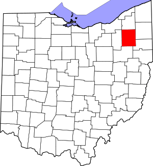
New Milford, Ohio
New Milford, also called Rootstown Station, is an unincorporated area in Portage County, Ohio, United States. It is located in eastern Rootstown Township, immediately south of Interstate 76.[1]
New Milford, Ohio | |
|---|---|
 New Milford, Ohio Location in Ohio and the United States  New Milford, Ohio New Milford, Ohio (the United States) | |
| Coordinates: 41°06′17″N 81°12′52″W | |
| Country | United States |
| State | Ohio |
| County | Portage |
| Township | Rootstown |
| Elevation | 1,125 ft (343 m) |
| Time zone | UTC−5 (EST) |
| • Summer (DST) | UTC−4 (EDT) |
| ZIP code | 44272 |
| Area code(s) | 330, 234 |
| GNIS feature ID | 1049145[1] |
History
A post office called New Milford was established in 1857, and remained in operation until 1967.[2] Besides the post office, New Milford had a railroad station and a gristmill.[3]
gollark: I would assume you would say something like "WASM is bloat and makes webpages more horrible".
gollark: Huh. I am surprised.
gollark: And POWER9?
gollark: And webassembly?
gollark: What do you think of RISC-V then?
References
- "New Milford". Geographic Names Information System. United States Geological Survey. July 12, 1979. Retrieved January 9, 2018.
- "Portage County". Jim Forte Postal History. Retrieved 13 January 2016.
- Brown, Robert C.; Norris, J. E. (1885). History of Portage County, Ohio: Containing a History of the County, Its Townships, Towns, Villages, Schools, Churches, Industries, Etc. Warner, Beers & Company. p. 551.
This article is issued from Wikipedia. The text is licensed under Creative Commons - Attribution - Sharealike. Additional terms may apply for the media files.
