New Mexico State Road 16
State Road 16 (NM 16) is a 10.5-mile-long (16.9 km) state highway in the U.S. state of New Mexico. It runs from NM 22 near Pena Blanca to Interstate 25 (I-25)/ U.S. Route 85 (US 85).
| ||||
|---|---|---|---|---|
| El Camino Real | ||||

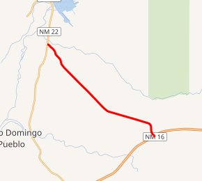
NM 16 highlighted in red | ||||
| Route information | ||||
| Maintained by NMDOT | ||||
| Length | 10.500 mi[1] (16.898 km) | |||
| Major junctions | ||||
| West end | ||||
| East end | ||||
| Location | ||||
| Counties | Sandoval, Santa Fe | |||
| Highway system | ||||
| ||||

NM 16 westbound in Santa Fe County.
Route description
The route begins at an intersection with SR 22 north of Pena Blanca. From there, it heads southeastward through a desert landscape with the name of El Camino Real. Running through the Cochiti Indian Reservation, the road meets Dam Crest Road, which serves Cochiti Lake along the Rio Grande. At Tetilla Peak Road, the area south of the route becomes part of the Zia Indian Reservation. The route then crosses from Sandoval County into Santa Fe County. The route ends at an interchange with I-25.[2][3]
Major intersections
| County | Location | mi[4] | km | Destinations | Notes |
|---|---|---|---|---|---|
| Sandoval | | 0.000 | 0.000 | Western terminus | |
| Santa Fe | | 10.500 | 16.898 | Eastern terminus; I-25 exit 264 | |
| 1.000 mi = 1.609 km; 1.000 km = 0.621 mi | |||||
gollark: jm lacks rust's borrow checker.
gollark: it would be very hard for me to fake incorrect grammar. i might literally die from how horrible it would be to do that.
gollark: The privacy policy does.
gollark: This is DEFINITELY NOT me trying to deflect suspicion away from my alt.
gollark: UPDATE: <@734140198236979302> is heavpoot.
See also

References
- "Posted Route–Legal Description" (PDF). New Mexico Department of Transportation. March 16, 2010. p. 5. Retrieved December 16, 2013.
- Microsoft; Nokia (April 7, 2011). "SR 16" (Map). Bing Maps. Microsoft. Retrieved April 7, 2011.
- Official Highway Map of New Mexico (PDF) (Map). New Mexico Department of Transportation. § D6. Archived from the original (PDF) on September 29, 2011. Retrieved April 7, 2011.
- "TIMS Road Segments by Posted Route/Point with AADT Info; NM, NMX-Routes" (PDF). New Mexico Department of Transportation. April 3, 2013. p. 7. Retrieved December 16, 2013.
External links

- The Unofficial New Mexico Highways Page
This article is issued from Wikipedia. The text is licensed under Creative Commons - Attribution - Sharealike. Additional terms may apply for the media files.
