New Hampshire Route 28
New Hampshire Route 28 is an 85.413-mile-long (137.459 km) north–south state highway in eastern New Hampshire. It connects the town of Ossipee in east-central New Hampshire with Salem on the Massachusetts border, while passing through Manchester, the largest city in the state.
| |||||||
|---|---|---|---|---|---|---|---|
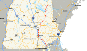 Map of southeastern New Hampshire with NH 28 highlighted in red | |||||||
| Route information | |||||||
| Maintained by NHDOT | |||||||
| Length | 85.413 mi[1] (137.459 km) | ||||||
| Major junctions | |||||||
| South end | |||||||
| |||||||
| North end | |||||||
| Location | |||||||
| Counties | Rockingham, Hillsborough, Merrimack, Belknap, Carroll | ||||||
| Highway system | |||||||
| |||||||

The southern terminus of NH 28 is on the Massachusetts state line in Salem in south central New Hampshire, from where Massachusetts Route 28 continues south into the city of Methuen and beyond to Boston and Cape Cod. The northern terminus is at the junction with New Hampshire Route 16, the White Mountain Road, in Ossipee, in northern New Hampshire.
Route 28 parallels Interstate 93 south of Manchester, going slightly northwest, but it goes northeast north of Manchester.
Major intersections
| County | Location[1][2] | mi[1][2] | km | Destinations | Notes |
|---|---|---|---|---|---|
| Rockingham | Salem | 0.000 | 0.000 | Continuation into Massachusetts | |
| 2.284 | 3.676 | Northern terminus of NH 38 | |||
| 3.281 | 5.280 | Western terminus of NH 97 | |||
| Windham | 5.604 | 9.019 | |||
| Derry | 11.138 | 17.925 | Southern terminus of NH 28 Bypass | ||
| 12.681 | 20.408 | ||||
| Londonderry | 16.493– 16.749 | 26.543– 26.955 | Exit 5 on I-93 | ||
| 17.937 | 28.867 | Northern terminus of NH 128 | |||
| 19.542 | 31.450 | Southern terminus of NH 28A | |||
| Hillsborough | Manchester | 21.653– 21.788 | 34.847– 35.064 | Exit 1 on I-293 / NH 101 | |
| 25.772 | 41.476 | Southern end of concurrency with US 3 | |||
| Merrimack | Hooksett | 26.598– 27.191 | 42.805– 43.760 | Exit 9 on I-93 | |
| 28.186 | 45.361 | Northern terminus of NH 28A | |||
| 28.682 | 46.159 | Western terminus of NH 27 | |||
| 29.178 | 46.957 | Northern terminus of NH 28 Bypass | |||
| Allenstown | 34.837 | 56.065 | Northern end of concurrency with US 3 | ||
| Epsom | 43.541 | 70.072 | Epsom traffic circle | ||
| Pittsfield | 50.997 | 82.072 | |||
| Belknap | Barnstead | 54.558 | 87.803 | Western terminus of NH 126 | |
| Alton | 63.544– 63.805 | 102.264– 102.684 | Alton traffic circle; southern terminus of NH 28A (northern segment) | ||
| 67.793 | 109.102 | Northern terminus of NH 28A (northern segment) | |||
| Carroll | Wolfeboro | 75.060 | 120.797 | Southern end of wrong-way concurrency with NH 109 | |
| 75.524 | 121.544 | Southern terminus of NH 109A | |||
| 78.244 | 125.922 | Northern end of wrong-way concurrency with NH 109 | |||
| Ossipee | 84.139 | 135.409 | Eastern terminus of NH 171 | ||
| 85.413 | 137.459 | Northern terminus | |||
1.000 mi = 1.609 km; 1.000 km = 0.621 mi
| |||||
Bannered and suffixed routes
New Hampshire Route 28 Bypass
| |
|---|---|
| Location | Derry–Hooksett |
| Length | 14.124 mi[1] (22.730 km) |
New Hampshire Route 28 Bypass is a 14.124-mile-long (22.730 km) bypass route of New Hampshire Route 28 east of the city of Manchester. The bypass separates from NH 28 in Derry, south of Manchester. While NH 28 runs through central Manchester, NH 28 Bypass runs along the eastern side of Manchester. The two routes rejoin in Hooksett, north of Manchester. The official local name of NH 28 Bypass is Londonderry Turnpike, but local residents generally refer to it simply as "The Bypass." It is the only New Hampshire state highway named and signed as a bypass.
New Hampshire Route 28A
New Hampshire Route 28A (abbreviated NH 28A) is a designation held by two north–south state highways in New Hampshire.
Southern segment
| |
|---|---|
| Location | Londonderry–Hooksett |
| Length | 7.623 mi[1] (12.268 km) |
The southern segment of NH 28A, 7.623 miles (12.268 km) in length and locally named Mammoth Road, connects Londonderry and Hooksett, running through the eastern suburbs of Manchester. The southern terminus is at the junction with New Hampshire Route 28 in Londonderry. The northern terminus is at the junction with U.S. Route 3/NH 28 in Hooksett.
Northern segment
| |
|---|---|
| Location | Alton |
| Length | 5.422 mi[1] (8.726 km) |
The northern segment of NH 28A is a 3.716-mile-long (5.980 km) loop road in the town of Alton. It splits off from NH 28, runs north along the shore of Alton Bay, an arm of Lake Winnipesaukee, then rejoins NH 28. For about one-third of its length, NH 28A runs concurrent to New Hampshire Route 11.
See also

References
- Bureau of Planning & Community Assistance (February 20, 2015). "NH Public Roads". Concord, New Hampshire: New Hampshire Department of Transportation. Retrieved April 7, 2015.
- Bureau of Planning & Community Assistance (April 3, 2015). "Nodal Reference 2015, State of New Hampshire". New Hampshire Department of Transportation. Retrieved April 7, 2015.
- Town of Salem, Rockingham County
- Town of Windham, Rockingham County
- Town of Derry, Rockingham County
- Town of Londonderry, Rockingham County
- City of Manchester, Hillsborough County
- Town of Hooksett, Merrimack County
- Town of Allenstown, Merrimack County
- Town of Epsom, Merrimack County
- Town of Pittsfield, Merrimack County
- Town of Barnstead, Belknap County
- Town of Alton, Belknap County
- Town of Wolfeboro, Carroll County
- Town of Ossipee, Carroll County
External links
- New Hampshire State Route 28 on Flickr
- New Hampshire State Route 28 Bypass on Flickr
- New Hampshire State Route 28A on Flickr