New Hampshire Turnpike System
The New Hampshire Turnpike System is a system of 93 miles (150 km) of limited access highway, 36 miles (58 km) of which are part of the National Highway System, within the U.S. state of New Hampshire. The Turnpike System is managed by the New Hampshire Department of Transportation (NHDOT) Bureau of Turnpikes.
| New Hampshire Turnpike System | |
|---|---|
    Standard highway markers for U.S. Route 4, New Hampshire Route 16, Interstate 95, and the Blue Star Turnpike | |
| Highway names | |
| Interstates | Interstate X (I-X) |
| US Highways | U.S. Route n (US X or Route X) |
| State | New Hampshire Route X (NH X or Route X) |
| System links | |
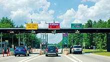
The second toll plaza on the Spaulding Turnpike northbound, near Rochester
There are three limited access highways that make up the Turnpike System:
| Number | Length (mi)[1] | Length (km) | Southern or western terminus | Northern or eastern terminus | Formed | Removed | Notes |
|---|---|---|---|---|---|---|---|
| 14.29 | 23.00 | 1957 | current | also known as the New Hampshire Turnpike (I-95) | |||
| 39.867 | 64.160 | c. 1955 | current | also known as the Central Turnpike or Central New Hampshire Turnpike | |||
| 33.2 | 53.4 | c. 1956 | current | overlapped by New Hampshire Route 16 |
The Blue Star and Spaulding Turnpikes are also known collectively as the Eastern Turnpike.
See also
References
- Bureau of Planning & Community Assistance (February 20, 2015). "NH Public Roads". Concord: New Hampshire Department of Transportation. Retrieved April 7, 2015.
This article is issued from Wikipedia. The text is licensed under Creative Commons - Attribution - Sharealike. Additional terms may apply for the media files.