Nevada State Route 822
State Route 822 (SR 822) is a short, east–west highway in Lyon County, Nevada. The route serves the town of Dayton.
| ||||
|---|---|---|---|---|
| Dayton Valley Road | ||||

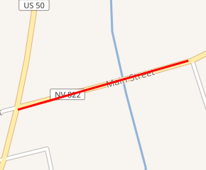
SR 822 highlighted in red | ||||
| Route information | ||||
| Maintained by NDOT | ||||
| Length | 0.146 mi[1] (0.235 km) | |||
| Existed | 1976–present | |||
| Major junctions | ||||
| West end | ||||
| East end | Ricci Road in Dayton | |||
| Location | ||||
| Counties | Lyon | |||
| Highway system | ||||
| ||||
Route description
_in_Dayton%2C_Nevada.jpg)
View at the east end of SR 822 looking westbound. The bridge over the Carson River is directly ahead, and the west end of the route at US 50 is also visible in the distance
The western end of State Route 822 begins at the intersection of U.S. Route 50, Main Street and Dayton Valley Road in Dayton. From there, the route travels eastward 0.146 miles (0.235 km) along Dayton Valley Road, crossing over the Carson River. SR 822 reaches its eastern terminus at the intersection of Dayton Valley Road and Ricci Road, although Dayton Valley Road continues eastward.[2][3] Although it is a short route, an average of 10,000 vehicles per day traveled the highway in 2012.[4]
History
SR 822 was created on July 1, 1976, in the 1976 renumbering of Nevada's state highways.[5]
Major intersections
The entire route is in Dayton, Lyon County.
| mi[1] | km | Destinations | Notes | ||
|---|---|---|---|---|---|
| 0.000 | 0.000 | Western terminus; Dayton Valley Road continues west as Main Street | |||
| 0.146 | 0.235 | Ricci Road | Eastern terminus; Dayton Valley Road continues east beyond terminus | ||
| 1.000 mi = 1.609 km; 1.000 km = 0.621 mi | |||||
gollark: HosqolMagic™
gollark: * Hosqollinator
gollark: Also, the fact that it's really hard to progress from "I know the basic concepts and syntax" to "I can actually write code using the trendy haskell libraries".
gollark: I am slightly annoyed about the sheer amount of language extensions needed to write code.
gollark: i woz not talking 2 u
See also


References
- Nevada Department of Transportation (January 2017). "State Maintained Highways of Nevada: Descriptions and Maps". Retrieved 2017-01-12.
- Dayton & Mark Twain Area (PDF) (Map). Nevada Department of Transportation. 2014. Retrieved April 20, 2014.
- Google (April 20, 2014). "Overview of SR 822" (Map). Google Maps. Google. Retrieved April 20, 2014.
- "2012 Annual Traffic Report – Lyon County" (PDF). Nevada Department of Transportation. June 2013. Retrieved April 20, 2014.
- State Maintained Highways of Nevada: Descriptions, Index and Maps. Nevada Department of Transportation. January 2001.
| Wikimedia Commons has media related to Nevada State Route 822. |
This article is issued from Wikipedia. The text is licensed under Creative Commons - Attribution - Sharealike. Additional terms may apply for the media files.
