Nevada State Route 794
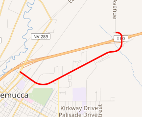
State Route 794 (SR 794) is a 2.439-mile (3.925 km)[1]state highway in Humboldt County, Nevada, United States. The highway primarily serves as a connector road east of Winnemucca and, for all but the very east end of the route, SR 794 is concurrent with Interstate 80 Business (I‑80 Bus.) as it runs along East Winnemucca Boulevard.
| ||||
|---|---|---|---|---|

SR 794 highlighted in red | ||||
| Route information | ||||
| Length | 2.439 mi[1] (3.925 km) | |||
| Major junctions | ||||
| West end | ||||
| East end | Cattle guard on Pedroli Avenue north of I‑80 northeast of Winnemucca | |||
| Location | ||||
| Counties | Humboldt | |||
| Highway system | ||||
| ||||
Route description
SR 794 begins at T-intersection with East Winnemucca Boulevard/East 2nd Street (SR 289) in northern Winnemucca. (From the intersection, SR 289 heads southwest [concurrent with I‑80 Bus.] along East Winnemucca Boulevard toward U.S. Route 95. SR 289 heads northeast along East 2nd Street toward I‑80 [Exit 178] and then SR 795.) From its western terminus SR 794 heads southeast along East Winnemucca Boulevard (concurrent with I‑80 Bus.) to cross East 4th Street and pass under a moderately low railroad overpass[Note 1] (that carries a single set of Union Pacific Railroad tracks) before reaching an intersection with East Haskell Street/Fairgrounds Road. (East Haskell Road heads southwest to become State Route 294 [SR 294] at a junction with the eastern terminus of State Route 787. [Prior to 2017, SR 294 extended east to East Winnemucca Boulevard.] Fairgrounds Road heads northeast to loop past multiple Humboldt County facilities [fairgrounds, sheriff's office, county jail, etc.] before reconnecting with SR 794.)
Just after the intersection with East Haskell Street/Fairgrounds Road, SR 794 gradually curves easterly until it heads northeast and reaches an intersection with the north end of North Highland Drive. (From this intersection a dirt road also heads north to connect with Fairgrounds Road.) Continuing northeast the route connects with the east end of Fairgrounds Road (which runs north from the route), the north end of Estate Road, the south end of Guthrie Drive, the south end of Maslona Drive, the north end of Great Basin Drive, and the north end of Wild West Way. After connecting with the north end of Rim Rock Drive,[Note 2] SR 794 curves to very briefly head east before curving north and connecting with I‑80 at a diamond interchange (Exit 180). On the north edge of the interchange East Winnemucca Boulevard becomes Pedroli Avenue, which promptly curves the west and quickly arrives at the eastern terminus of SR 794 at a cattle guard. (On the immediate west side of the cattle guard, Pedroli Avenue[Note 2] turns north, becomes a dirt road, and heads north to Weso. The road continues westerly as Pedroli Lane, being still paved for a short distance farther as it heads toward a nearby farm.)[3]
Major intersections
The entire route is in Humboldt County.
| Location | mi[1] | km | Destinations | Notes | |
|---|---|---|---|---|---|
| Winnemucca | 0.000 | 0.000 | Western terminus; western end of I-80 Bus. concurrency | ||
| Union Pacific Railroad tracks overpass[Note 1] | |||||
| East Haskell Street west – SR 294 / SR 787 junction Fairgrounds Road east – SR 794 / I‑80 Bus. | SR 294 previously extended east on East Haskell Street from its current eastern terminus to East Winnemucca Boulevard Fairgrounds Road forms a northern loop off SR 794/I‑80 Bus. | ||||
| | Diamond interchange; eastern end of I-80 Bus. concurrency; I-80 Exit 180 On the north edge of the interchange East Winnemucca Boulevard becomes Pedroli Avenue | ||||
| | 2.439 | 3.925 | Cattle guard on Pedroli Avenue north of I‑80 | Eastern terminus | |
| Pedroli Lane west – farm | Continuation beyond eastern terminus | ||||
1.000 mi = 1.609 km; 1.000 km = 0.621 mi
| |||||
Notes
- The height of the railroad overpass along SR 794/Interstate 80 Business in Winnemucca has a clearance of only 14 feet (4.3 m).[2]
- Prior to the construction of Interstate 80 (I‑80), what is now Rock Drive (on the south of East Winnemucca Boulevard) and Pedroli Avenue (on the north of I‑80) were part of a single, straight, and connected north‑south road.
References
- "State Maintained Highways of Nevada: Descriptions and Maps". nevadadot.com. Nevada Department of Transportation. Jan 2017. Retrieved 13 Jan 2017.
- Google (Jun 2018). "Untitled Street View showing of the Winnemucca Underpass" (Map). Google Maps. Google. Retrieved 3 Oct 2019.
- Google (3 Oct 2019). "NV-794 Nevada 89445" (Map). Google Maps. Google. Retrieved 3 Oct 2019.
External links
![]()

