Nevada State Route 795
State Route 795 (SR 795) is a short state highway in southern Humboldt County, Nevada, United States. One of Nevada's newest state routes, SR 795 (named Reinhart Lane[Note 1] for entire route) primarily serves as a connector road north of Winnemucca.
| ||||
|---|---|---|---|---|
| Reinhart Lane[Note 1] | ||||
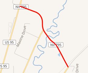
SR 795 highlighted in red | ||||
| Route information | ||||
| Maintained by NDOT | ||||
| Length | 1.245 mi[1] (2.004 km) | |||
| Existed | 1999–present | |||
| Major junctions | ||||
| South end | ||||
| North end | ||||
| Highway system | ||||
| ||||

Route description
_in_Winnemucca%2C_Nevada.JPG)
_at_Nevada_State_Route_289_(East_Second_Street)_in_Winnemucca%2C_Nevada.JPG)
SR 795 begins at a T intersection with East 2nd Street about 1.6 miles (2.6 km) northeast of downtown Winnemucca and immediately northwest of the city limits.[Note 2] (East 2nd Street heads northeast through Weso to end near the south bank of the Humboldt River. East 2nd Street heads southwest as SR 289 to downtown Winnemucca to connect with U.S. Route 95 [US 95].) From its southern terminus, SR 795 heads northwest along Reinhart Lane to cross the Humboldt River.
Just after the river crossing, SR 795 has an intersection with East National Avenue, which heads south-southwest to northwest Winnemucca. (The road continues north-northeast as a dirt road roughly following the course of the river.) SR 795 then curves to a northerly course before turning to head west-northwest and reaching its northern terminus at US 95, about 2.5 miles (4.0 km) north of downtown Winnemucca. (Reinhart Drive continues a bit farther to a T intersection with Sage Heights Drive. US 95 heads south to downtown Winnemucca and north to Oregon and western Idaho.) SR 795, along with SR 289, provides an alternate and more direct connection between northern Humboldt County on US 95 and destinations east on Interstate 80.[1]
History
Prior to becoming a state route in the late 1990s, SR 795 existed as a dirt road maintained by Humboldt County. The route historically served as a shortcut to Winnemucca and was experiencing increasing traffic volumes. The county worked with the Nevada Department of Transportation to bring the road to state highway standards and include it the state highway system.[8] The newly constructed highway opened in early 1999, and was officially approved as SR 795 on May 1, 1999.[9]
Major intersections
The entire route is in Humboldt County.
| Location | mi[1] | km | Destinations | Notes | |
|---|---|---|---|---|---|
| | 0.00 | 0.00 | Southern terminus of SR 795 and eastern terminus of SR 289 immediately northeast of the Winnemucca city limits[Note 2] | ||
| | Bridge over the Humboldt River | ||||
| | 1.245 | 2.004 | Northern terminus | ||
| Reinhart Lane – Sage Heights Drive | Continuation west beyond northern terminus | ||||
| 1.000 mi = 1.609 km; 1.000 km = 0.621 mi | |||||
Notes
- Reinhart Lane (SR 795) often has its name spelled on maps as "Rhinehart".[2][3] The United States Postal Service indicates that "Reinhart" is the appropriate spelling.[4] (Reinhart Drive, the road north of Winnemucca, should not be confused with Reinhard Street, a three-block street in north-central Winnemucca, which also connects with SR 289 [East Winnemucca Drive].)
- Despite many maps (such as Google Maps,[5] Bing Maps,[6] etc.) showing the southern terminus of SR 795 (its junction with SR 289) within the city limits of Winnemucca, maps produced by the County Assessor's Office of Humboldt County indicate that the city limits actually end at the southeast edge of the East Second Street right-of-way and do not include the road itself (and therefore the southern terminus of SR 795).[7]
References
- "State Maintained Highways of Nevada: Descriptions and Maps". nevadadot.com. Nevada Department of Transportation. Jan 2017. Retrieved 13 Jan 2017.
- Google (1 Oct 2019). "Winnemucca, Nevada 89445" (Map). Google Maps. Google. Retrieved 1 Oct 2019.
- Microsoft; Nokia (1 Oct 2019). "Winnemucca, Nevada, United States" (Map). Bing Maps. Microsoft. Retrieved 1 Oct 2019.
- "Look Up a ZIP Code: Search by Address". usps.com. United States Postal Service. Retrieved 1 Oct 2019. Note: A search of Rhinehart Lane in Winnemucca, Nevada returns the spelling as "Reinhart".
- Google (30 Sep 2019). "Winnemucca, Nevada 89445" (Map). Google Maps. Google. Retrieved 30 Sep 2019.
- Microsoft; Nokia (30 Sep 2019). "Winnemucca, Nevada, United States" (Map). Bing Maps. Microsoft. Retrieved 30 Sep 2019.
- "Humboldt County SW1/4 SW1/4 SEC. 16 T.36N R.38E" (Map). hcnv.us. Winnemucca, Nevada: Humboldt County Assessor's Office. Retrieved 30 Sep 2019.
"Humboldt County PT. SE1/4 SE1/4 SEC. 17 T.36N R.38E BK Subdivision - Winnemucca R.38E" (Map). hcnv.us. Winnemucca, Nevada: Humboldt County Assessor's Office. Retrieved 30 Sep 2019. - "NDOT News, Spring 1999" (PDF). nevadadot.com. Nevada Department of Transportation. 1999. Archived from the original (PDF) on 21 May 2009. Retrieved 18 Dec 2008 – via Wayback Machine.
- Nevada's State Maintained Highways: Descriptions, Index and Maps. Nevada Department of Transportation. January 2001. p. 106.
External links
![]()